-
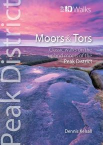 This lovely, pocket size book offers the ten best short circular walks to upland moors and tors across the Peak District. The uplands of the Peak bear the characteristics of hills rather than mountains: high, undulating plateaux dissected by deep, meandering valleys. Yet there is little uniformity; the seemingly remote moorland of the Kinder plateau is in sharp contrast to the gentler and lower upland heaths found farther south. These landscapes change subtly with the seasons and, for those who care to look, are rich in wildlife. There are birds, hares, and foxes; and in summer, adders and lizards bask in the sun while butterflies dance in the remotest places.
 -
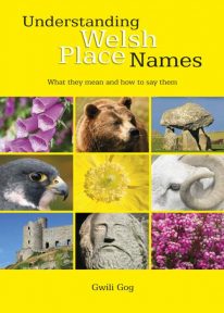 Puzzled by Welsh place names but want to know what they mean and how to say them? This fascinating, easy-to-use guide means non-Welsh speakers can now easily translate and understand place names all over Wales — on the map, on road signs, and out in the countryside. Armed with this insider knowledge, you’ll discover there’s a whole exciting new dimension to the Welsh landscape. In fact, Wales will never be quite the same again ….
 -
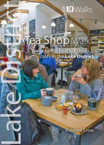 A visit to a tea shop adds something special to a walk. It’s always a treat to sit down to coffee and cake at the end of an afternoon stroll or to tuck into a hearty lunch half-way through a gorgeous hike. From quaint little tea rooms that still serve drinks in china cups to modern cafés staffed by trained baristas, the Lake District has plenty to offer — and all surrounded by a truly breathtaking UNESCO World Heritage landscape. The ten tea shops in this book have been chosen partly on the basis of the excellent walking that can be enjoyed from their doors, and partly on the basis of the fare and ambience they have to offer. They occupy village, lakeside and woodland locations. The walks themselves take in hidden valleys, low fells, lakes, waterfalls, riverside paths, fabulous viewpoints and wildflower-filled woods — a tremendous array of the sort of scenery for which the Lake District has become world famous.
 -
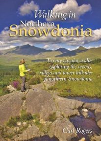 This attractive book explores twenty of the best low level circular walks in northern Snowdonia. Walking in Northern Snowdonia is dedicated to the northern half of the National Park, bounded by the Conwy Valley to the east, Glyn Lledr and the Vale of Ffestiniog to the south and Cwm Pennant to the west. Twenty circular walks are described, ranging in length from 4½ to 9 miles, which explore the woods, valleys and lower hillsides of this unique and beautiful area.
 -
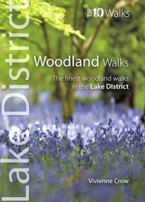 This lovely little book will take you on ten short circular walks through the finest woods and forests in the Lake District People seem to be drawn to trees, be they part of a landscape that has existed for centuries or planted in more modern times. There is something special about being in among their sturdy trunks, surrounded by a rich understorey with the sunlight piercing the canopy high above. In the Lake District, there is a huge variety of woodland — and no matter what their origins, what tree types grow there or how they have been managed, that extraordinary atmosphere never fails to nourish the soul.
 -
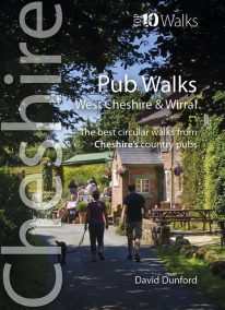 This handy, wonderfully illustrated little guidebook gives walkers the ten best short circular walks to some of the very best country pubs and inns in Cheshire and Wirral in a handy, pocketable format. As befits a well-heeled, fertile county with a rich farming heritage, the country pubs and inns of Cheshire and Wirral are hugely rewarding to visitors and walkers. From numerous candidates we’ve whittled the list down to personal favourites that balance a lack of pretention with good service, and are also blessed with pleasant locations and rewarding walks from the doorstep, while attempting a representative geographical distribution covering the range of landscapes of this diverse county.
 -
Land's End to Plymouth
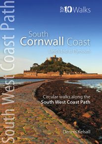
The ten walking routes featured here highlight the best short circular walks along the South Cornwall Coast section of the popular, 630-mile long South West Coast Path (SWCP). Running from Land's End at the very western tip of England to Penlee Point, guarding the entrance to Plymouth Sound, Cornwall's deeply convoluted south coast is infinitely varied, ranging from rugged cliffs braced against the full force of Atlantic waves to the sheltered Cornish Riviera where the weather, scenery and flora can be almost Mediterranean. Large towns are few, but attractive villages, hamlets and harbours abound, usually with a welcoming pub or café not far away. The five-book series of 'Top Ten Walks' covers the whole of the UK's famous South West Coast Path. Each book explores the highlights along the way; showcasing its natural beauty, wildlife and heritage. Once you've tasted what the South Cornwall section has to offer, we think you'll be inspired to come back to tackle the complete trail. -
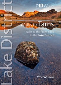 This smashing little book features ten short circular walks to the loveliest tarns in the Lake District. Norsemen, who dominated Lakeland 1,000 years ago, called the small bodies of water they found in the mountains tjorns—‘little lakes’ or , literally, ‘teardrops’. Now known as tarns, they are remnants of the last Ice Age when huge ice sheets scoured out hollows in the mountains that then filled with water. There are hundreds of tarns in the Lake District National Park: from tiny pools sparkling like blue jewels on high, lonely ridge tops, to small lakes sitting cold and moody at the base of sombre cliffs.
 -
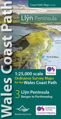 Enhanced, large scale (1: 25,000) Ordnance Survey mapping in a handy atlas format with all the mapping you need to walk a complete circuit of the Anglesey section of the Wales Coast Path. Continuous OS mapping covering the complete route from Bangor to Porthmadog. Contains coastal extracts from large scale Explorer maps 253 and 254. The Llyn Peninsula Ordnance Survey mapping book is part of a series of map atlases covering the whole of the 870-mile long Wales Coast Path. The enhanced OS 1:25,000 maps are accurate, up-to-date and reliable. Additional map symbols show tea shops, cafes, extra parking, and public toilets. A brief introduction to the Llyn Peninsula includes a fascinating photo mosaic highlighting notable views, places of interest and wildlife you'll meet along the way. There is also a section of detailed Useful Information at the back of the atlas. Laminated flapped covers showing Wales Coast Path signs and waymarkers, route details and map symbols make these atlases simple and easy to use. The map books’ dimensions are 215mm x 107mm and they fit easily into a standard map pocket.
- Large scale Ordnance Survey Explorer mapping for the complete coast of the Llyn Peninsula in a handy atlas format.
- Highlighted official route of the Wales Coast Path.
- On-map symbols showing amenities at main towns and villages.
- Introduction with attractive photo mosaic.
- Additional useful information
-
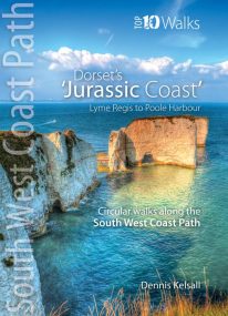
Lyme Regis to Poole Harbour
The ten walks featured here highlight the best short circular walks along Dorset's iconic 'Jurassic Coast' section of the South West Coast Path. The Dorset coast is perhaps the most varied of the whole south western peninsula, encompassing glorious beaches, towering cliffs, detached stacks, long shingle banks and picturesque coves and inlets. The handiwork of man both past and present is there too, in settlement, quarrying and even oil extraction. But there is little to detract from the coast’s overall beauty — and the coast’s huge range of habitats is reflected in the sheer abundance of flowers and wildlife you’ll experience along the way. -

Snowdon - Neck Gaiter/Scarf/Snood
Wearable large-scale 1:25,000 Ordnance Survey map artwork: Snowdon in Snowdonia
SNOWDON IS THE HIGHEST AND MOST POPULAR MOUNTAIN IN WALES. Also known as 'The Top of Wales', it reaches 1,085 metres (3,560 ft) above sea level. This detailed Ordnance Survey mapping snood shows the summit and six main routes of ascent, making it the ideal present or souvenir for everyone who reaches, or dreams of reaching, the top Note: While the Ordnance Survey mapping used on the snood is up-to-date at the time of production, it is not recommended for navigation. Walkers should carry the correct OS online or sheet map and compass.Ordnance Survey Licence No.: 0100047867
-
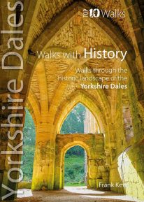 This lovely little book will take you on short circular walks to some of the Yorkshire Dales' most intriguing ancient and historic sites. From mysterious prehistoric rock carvings, Iron Age field systems, Roman roads, and medieval castles, to the very names given to hills, valleys, farms and villages, the Yorkshire Dales are steeped in the histories of countless generations of people who have made the Dales their home. The ten walks featured here visit some of these iconic sites, whether in wild open moorland, or in gentler bucolic farmland. Enjoy superb walking in historic Yorkshire landscapes that resonate with the memory of past lives.