-
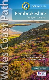 NEW, updated and revised edition - 2021 One of seven Official Guides to the Wales Coast Path The 186 mile/300km long Pembrokeshire section of the Wales Coast Path runs through some of Wales’ most varied and dramatic coastal scenery — high, rugged cliffs and long sandy bays, Pembroke Castle, St David’s cathedral and St Govan’s remote cliff-wrapped chapel, with several large offshore islands. Pembrokeshire is also Britain’s only coastal National Park. This Official Guide splits the route into 14 convenient day sections, each of about 10-17 miles / 16-27 kilometres. It contains everything local and long-distance walkers need to enjoy the path.
 -
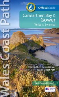 NEW, updated and revised edition - 2021 One of seven Official Guides to the Wales Coast Path The Carmarthen Bay and Gower section of the Wales Coast Path runs for 120 miles/193 kilometres between Amroth, on the eastern edge of the Pembrokeshire Coast National Park, to Swansea, on the landward side of the Gower Peninsula. This Official Guide splits the route into 12 convenient day sections, each of about 10-17 miles / 16-27 kilometres. It contains everything local and long-distance walkers need to enjoy the path and includes: An overview of Carmarthen Bay and Gower with dedicated history and wildlife sections Twelve day-walk sections with detailed route descriptions and full, enhanced Ordnance Survey mapping Distance charts, section overviews, background information and interpretation of places of interest Stunning professional photographs throughout Information on accommodation, public transport, local information, weather, and tidal links.
 -
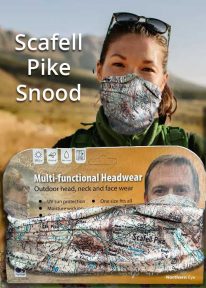
Scafell Pike - Neck Tube/Scarf/Snood
Wearable large-scale 1:25,000 Ordnance Survey map artwork: Scafell Pike in the Lake District
CELEBRATE ENGLAND'S HIGHEST MOUNTAIN and one of the National Three Peaks Challenge summits with this attractive modern Ordnance Survey 1:25,000 scale mapping snood or neck warmer. It looks great and will keep you snug and comfortable on the way up and down. The perfect gift or souvenir for everyone who climbs - or is about to climb - this iconic peak. Note: While the Ordnance Survey mapping used on the snood is up-to-date at the time of production, it is not recommended for navigation. Walkers should carry the correct OS online or sheet map and compass.Ordnance Survey Licence No.: 0100047867
-

Snowdon - Neck Gaiter/Scarf/Snood
Wearable large-scale 1:25,000 Ordnance Survey map artwork: Snowdon in Snowdonia
SNOWDON IS THE HIGHEST AND MOST POPULAR MOUNTAIN IN WALES. Also known as 'The Top of Wales', it reaches 1,085 metres (3,560 ft) above sea level. This detailed Ordnance Survey mapping snood shows the summit and six main routes of ascent, making it the ideal present or souvenir for everyone who reaches, or dreams of reaching, the top Note: While the Ordnance Survey mapping used on the snood is up-to-date at the time of production, it is not recommended for navigation. Walkers should carry the correct OS online or sheet map and compass.Ordnance Survey Licence No.: 0100047867
-
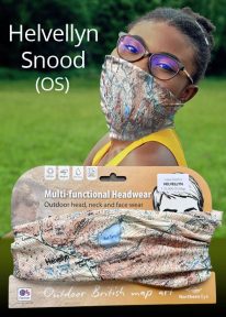
Helvellyn - Neck Gaiter/Scarf/Snood
Wearable large-scale 1:25,000 Ordnance Survey map artwork: Helvellyn in the Lake District
HELVELLYN IS ONE OF THE LAKE DISTRICT'S MOST POPULAR PEAKS at 950 metres / 3,118 feet above sea level. The luxurious, silky neck tube features wearable large-scale 1:25,000 Ordnance Survey map artwork. Now you or a friend can own this stylish and permanent souvenir of an iconic mountain. Note: While the Ordnance Survey mapping used on the snood is up-to-date at the time of production, it is not recommended for navigation. Walkers should carry the correct OS online or sheet map and compass.Ordnance Survey Licence No.: 0100047867
-
Coming Soon
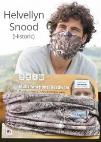
Helvellyn - Neck Gaiter/Scarf/Snood
Wearable large-scale historic map artwork: Helvellyn in the Lake District
HELVELLYN HAS BEEN A POPULAR CUMBRIAN SUMMIT FOR MANY YEARS. The snood's tightly woven material features a detailed historic colour map dating from 1912 — and shows the mountain in all its timeless beauty. A wonderful keepsake, gift or souvenir Note: The historic mapping used on this snood is not recommended for navigation. Walkers should carry the correct modern OS online or sheet map and compass. -
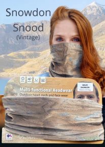
Snowdon - Neck Gaiter/Scarf/Snood
Wearable large-scale historic (1912) map artwork: Snowdon in Snowdonia
SOMETIMES CALLED 'THE TOP OF WALES', Snowdon is the highest and best-known peak in the country, reaching 1,085 metres (3,560 ft) above sea level. This historic, 1912 Ordnance Survey map snood shows the summit and all six main paths up, making it the ideal gift or souvenir for mountain fans everywhere. Note: The historic mapping used on this snood is not recommended for navigation. Walkers should carry the correct modern OS online or sheet map and a compass. -
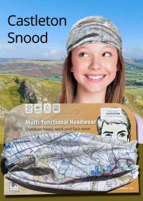
Peak District: Castleton - Neck Gaiter/Scarf/Snood
Wearable large-scale 1:25,000 Ordnance Survey map artwork: Castleton in the Peak District
CASTLETON AND THE GREAT RIDGE LIE AT THE HEART OF THE PEAK DISTRICT. This attractive, silky smooth snood features historic coloured map artwork showing the area in detail. The perfect souvenir or gift. Note: While the Ordnance Survey mapping used on the snood is up-to-date at the time of production, it is not recommended for navigation. Walkers should carry the correct OS online or sheet map and compass.Ordnance Survey Licence No.: 0100047867
-
Coming Soon

Scotland: Ben Nevis - Neck Gaiter/Scarf/Snood
Wearable large-scale 1:50,000 Ordnance Survey map artwork: Ben Nevis in Scotland
BEN NEVIS IS THE HIGHEST MOUNTAIN IN SCOTLAND AND THE BRITISH ISLES. Rising to 1,345 metres (4,413 ft) above sea level, the summit is reached by around 100,000 visitors a year. This detailed Ordnance Survey mapping snood shows the mountain and its awe-inspiring surroundings, making it the ideal present or souvenir for everyone who loves this most famous of Scotland's mountains. Note: While the Ordnance Survey mapping used on the snood is up-to-date at the time of production, it is not recommended for navigation. Walkers should carry the correct OS online or sheet map and compass.Ordnance Survey Licence No.: 0100047867
-
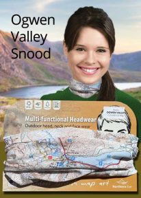
Wales: Tryfan & the Glyders - Neck Gaiter/Scarf/Snood
Wearable large-scale 1:25,000 Ordnance Survey map artwork: Tryfan & the Glyders in Snowdonia
WALES' FAMOUS OGWEN VALLEY is home to the shallow, ribbon lake of Llyn Ogwen (alongside the main A5) , which divides the two main mountain rages of the Snowdonia National Park — the Carneddau and the Glyderau. Key mountains here include mighty Tryfan and the Glyders. This detailed Ordnance Survey mapping snood shows the lake and its dramatic surroundings, making it the ideal present or souvenir for everyone who loves this iconic valley and its surrounding peaks. Note: While the Ordnance Survey mapping used on the snood is up-to-date at the time of production, it is not recommended for navigation. Walkers should carry the correct OS online or sheet map and compass.Ordnance Survey Licence No.: 0100047867
-
Coming Soon
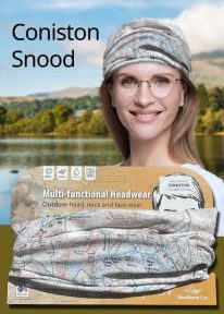
Lake District: Coniston - Neck Gaiter/Scarf/Snood
Wearable large-scale 1:25,000 Ordnance Survey map artwork: Coniston in the Lake District
CONISTON IS ONE OF THE LAKE DISTRICT'S LOVELIEST LAKES. Over five miles long and surrounded by the Cumbrian fells, Coniston is a justified favourite with visitors. The luxurious, silky neck tube features wearable large-scale 1:25,000 Ordnance Survey map artwork. Now you or a friend can own this stylish and permanent souvenir of an iconic part of the English Lake District. Note: While the Ordnance Survey mapping used on the snood is up-to-date at the time of production, it is not recommended for navigation. Walkers should carry the correct OS online or sheet map and compass.Ordnance Survey Licence No.: 0100047867
-
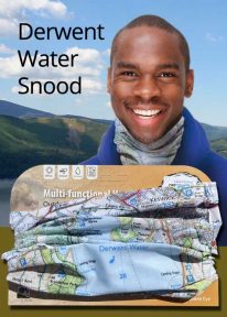
Lake District: Derwentwater - Neck Gaiter/Scarf/Snood
Wearable large-scale 1:25,000 Ordnance Survey map artwork: Derwentwater in the Lake District
DERWENT WATER IS ONE OF THE LAKE DISTRICT'S MOST POPULAR LAKES. Surrounded by fells, the island-dotted lake is three miles long and lies just to the south of Keswick. This luxurious, silky neck tube features wearable large-scale 1:25,000 Ordnance Survey map artwork of the lake and its beautiful shore. Now you or a friend can own this stylish and permanent souvenir of an iconic part of the English Lakes. Note: While the Ordnance Survey mapping used on the snood is up-to-date at the time of production, it is not recommended for navigation. Walkers should carry the correct OS online or sheet map and compass.Ordnance Survey Licence No.: 0100047867
-
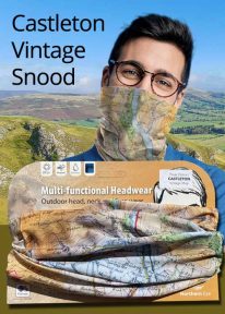
Peak District: Castleton (Vintage) - Neck Gaiter/Scarf/Snood
Wearable large-scale historic map artwork: Castleton in the Peak District
CASTLETON AND THE GREAT RIDGE LIE AT THE HEART OF THE PEAK DISTRICT NATIONAL PARK. The ever-popular town lies between the gentle limestone 'White Peak' to the south, and the starker gritstone 'Dark Peak' to the north. This attractive, silky smooth snood features historic coloured map artwork showing the area in detail. Note: The historic mapping used on this snood is not recommended for navigation. Walkers should carry the correct modern OS online or sheet map and compass. -

Wales: Cadair Idris - Neck Gaiter/Scarf/Snood
Wearable large-scale 1:25,000 Ordnance Survey map artwork: Cadair Idris in Snowdonia
CADAIR IDRIS IS THE SECOND-HIGHEST MOUNTAIN IN THE SNOWDONIA NATIONAL PARK. Rightly popular with walkers, it stands at the southern end of the National Park near Dolgellau. This detailed Ordnance Survey mapping snood shows the shapely mountain and its three main routes of ascent, making it the ideal present or souvenir for everyone who has climbed, or dreams of climbing, this wonderful summit. Note: While the Ordnance Survey mapping used on the snood is up-to-date at the time of production, it is not recommended for navigation. Walkers should carry the correct OS online or sheet map and compass.Ordnance Survey Licence No.: 0100047867
-
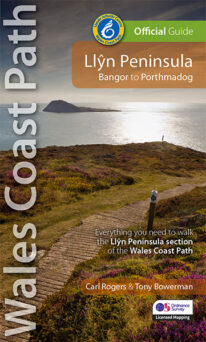 NEW - 4th edition updated and revised – 2023 This Official Guide to the Llŷn Peninsula section of the Wales Coast Path contains everything local and long-distance walkers need. The Llŷn offers some of the finest coastal walking in North Wales. Its distinctive landscape is characterised by traditional farms, compact villages and volcanic hills encircled by the ever-present sea. Along the way, you'll pass Iron Age hillforts, pilgrims' churches, medieval castles, a hidden valley, a pub on the beach, tiny coves, sandy bays and Bardsey island balanced at the tip of this ancient 'Land's End of Wales'. Keep an eye out, too, for seabirds, wild goats, choughs, seals, dolphins, wildflowers and butterflies. The Llŷn coast path really is a walkers' paradise.
 -
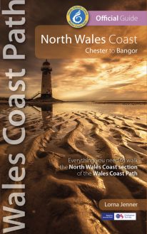 New Edition - rewalked and updated 2022 One of seven Official Guides to the Wales Coast Path The 80 mile/125km long North Wales Coast section of the Wales Coast Path between Chester and Bangor runs alongside the broad Dee Estuary and traditional seaside towns past Conwy Castle, the Great Orme, Penmaenmawr and Conwy Mountain to the university town of Bangor on the Menai Strait. This Official Guide splits the route into 8 convenient day sections, each of about 9-12 miles / 14-20 kilometres. It contains everything local and long-distance walkers need to enjoy the path.
 -
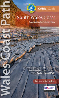 One of seven Official Guides to the Wales Coast Path The 115 mile/185km long South Wales Coast section of the Wales Coast Path runs through unexpectedly varied and dramatic coastal scenery. Along the way are four National Nature Reserves and some 14 miles of designated Heritage Coast, while the deserted salt marshes and mudflats bordering the later stages of the route alongside the mouth of the River Severn are a bird-watchers' paradise. This Official Guide splits the route into nine achievable day sections, each of about 10-17 miles / 16-27 kilometres. It contains everything local and long-distance walkers need to enjoy the path.
 -
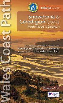 NEW, updated and revised edition – 2022 One of seven Official Guides to the Wales Coast Path The Snowdonia & Ceredigion coast offers a tremendous variety of landscape to those who walk its entire 132 miles/213 kilometres: from high, airy cliff-tops to secluded coves; from estuarine salt marshes to beaches backed by tremendous dune systems that stretch on for miles. And with that diversity comes a huge range of wildlife, including seabirds, choughs, dolphins and rare wildflowers. The history too changes with every twist and turn of this fascinating route: visitors should always be prepared for the unexpected in a region that contains the ruins of once mighty castles and has links with characters as disparate as King Arthur and members of the rock band Led Zeppelin.