-
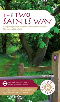 An impressive guide book that coincides with the growing interest in pilgrimage as an aspect of ‘wellness’ tourism that benefits body, mind and spirit. The guide is packed with information both practical and historical. It is an attractive publication with OS map extracts and numerous high quality colour photos. The Two Saints Way has a symmetrical structure with the two cathedrals at either end, Stoke Minster in the middle and two churches dedicated to St Mary at the quarter points. With this in mind, the 92 mile route is divided into four colour coded sections - 1: Chester to Nantwich, 2: Nantwich to Stoke, 3: Stoke to Stafford and 4: Stafford to Lichfield. Each section is further divided into four stages of between 3.5 and 8.5 miles in length. The route is described in both directions. Highlights on this varied route include Beeston Castle, Englelsea Brook Chapel and Museum, the Staffordshire Hoard at the Potteries Museum, Trentham Gardens and Cannock Chase Area of outstanding Natural Beauty. The guide contains a wealth of fascinating information on many features of interest.
 -
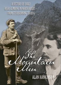 The fascinating inside story of pioneer rock climbers in Snowdonia, from the closing decades of the nineteenth century until the outbreak of the First World War.
 -
 This book is a climbing classic. Hardback. The Day the Rope Broke is the gripping tale of the ascent and tragic descent of the Matterhorn in 1865.
 -
 If you've ever climbed Snowdon/Yr Wyddfa (or even just dream of climbing Snowdon) - Wales' highest mountain - then this stylish, superb quality sew-on embroidered patch makes a great souvenir, keepsake or gift.
- Eye-catching, modern design
- Full colour
- Embroidered
- 80mm high
- Contrasting stitched edge
- Colourfast and washable
- Designed in Wales
-
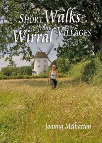 The 30 short circular walks in this book have been written with the non-serious walker in mind, varying in length from just 1 to 4¾ miles (1.5km to 7.5km). Each walk has something of interest to discover — you will visit the site of an ancient port now completely dried out and over a mile inland; a seafront with neither sand nor sea; a wild, wooded river valley in the heart of industrial Merseyside and a lowland heath with wide views to the Welsh hills
 -
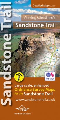
Large-scale Ordnance Survey maps for walking Cheshire's Sandstone Trail in a handy pocket size book.
Cheshire’s Sandstone Trail is probably the most popular middle-distance walk in Northwest England. Here, in handy, pocket size book format are all the maps you need to walk Cheshire's entire 55 kilometre/34 mile Trail.- Enlarged and enhanced, large scale 1:25,000 Ordnance Survey mapping for the whole Sandstone Trail
- Up-to-date route of Sandstone Trail clearly highlighted in yellow
- Extra map symbols for pubs, tea rooms, parking and more
- Trail introduction and photo mosaic
- Useful information section
- Ideal for walkers and all outdoor enthusiasts along Cheshire's sandstone ridge
- Contains relevant mapping from two OS maps for the price of one
-
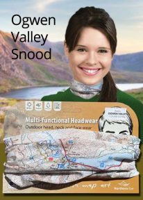
Wales: Tryfan & the Glyders - Neck Gaiter/Scarf/Snood
Wearable large-scale 1:25,000 Ordnance Survey map artwork: Tryfan & the Glyders in Snowdonia
WALES' FAMOUS OGWEN VALLEY is home to the shallow, ribbon lake of Llyn Ogwen (alongside the main A5) , which divides the two main mountain rages of the Snowdonia National Park — the Carneddau and the Glyderau. Key mountains here include mighty Tryfan and the Glyders. This detailed Ordnance Survey mapping snood shows the lake and its dramatic surroundings, making it the ideal present or souvenir for everyone who loves this iconic valley and its surrounding peaks. Note: While the Ordnance Survey mapping used on the snood is up-to-date at the time of production, it is not recommended for navigation. Walkers should carry the correct OS online or sheet map and compass.Ordnance Survey Licence No.: 0100047867
-

Wales: Cadair Idris - Neck Gaiter/Scarf/Snood
Wearable large-scale 1:25,000 Ordnance Survey map artwork: Cadair Idris in Snowdonia
CADAIR IDRIS IS THE SECOND-HIGHEST MOUNTAIN IN THE SNOWDONIA NATIONAL PARK. Rightly popular with walkers, it stands at the southern end of the National Park near Dolgellau. This detailed Ordnance Survey mapping snood shows the shapely mountain and its three main routes of ascent, making it the ideal present or souvenir for everyone who has climbed, or dreams of climbing, this wonderful summit. Note: While the Ordnance Survey mapping used on the snood is up-to-date at the time of production, it is not recommended for navigation. Walkers should carry the correct OS online or sheet map and compass.Ordnance Survey Licence No.: 0100047867
-
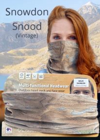
Snowdon - Neck Gaiter/Scarf/Snood
Wearable large-scale historic (1912) map artwork: Snowdon in Snowdonia
SOMETIMES CALLED 'THE TOP OF WALES', Snowdon is the highest and best-known peak in the country, reaching 1,085 metres (3,560 ft) above sea level. This historic, 1912 Ordnance Survey map snood shows the summit and all six main paths up, making it the ideal gift or souvenir for mountain fans everywhere. Note: The historic mapping used on this snood is not recommended for navigation. Walkers should carry the correct modern OS online or sheet map and a compass. -

Snowdon - Neck Gaiter/Scarf/Snood
Wearable large-scale 1:25,000 Ordnance Survey map artwork: Snowdon in Snowdonia
SNOWDON IS THE HIGHEST AND MOST POPULAR MOUNTAIN IN WALES. Also known as 'The Top of Wales', it reaches 1,085 metres (3,560 ft) above sea level. This detailed Ordnance Survey mapping snood shows the summit and six main routes of ascent, making it the ideal present or souvenir for everyone who reaches, or dreams of reaching, the top Note: While the Ordnance Survey mapping used on the snood is up-to-date at the time of production, it is not recommended for navigation. Walkers should carry the correct OS online or sheet map and compass.Ordnance Survey Licence No.: 0100047867
-
Coming Soon

Scotland: Ben Nevis - Neck Gaiter/Scarf/Snood
Wearable large-scale 1:50,000 Ordnance Survey map artwork: Ben Nevis in Scotland
BEN NEVIS IS THE HIGHEST MOUNTAIN IN SCOTLAND AND THE BRITISH ISLES. Rising to 1,345 metres (4,413 ft) above sea level, the summit is reached by around 100,000 visitors a year. This detailed Ordnance Survey mapping snood shows the mountain and its awe-inspiring surroundings, making it the ideal present or souvenir for everyone who loves this most famous of Scotland's mountains. Note: While the Ordnance Survey mapping used on the snood is up-to-date at the time of production, it is not recommended for navigation. Walkers should carry the correct OS online or sheet map and compass.Ordnance Survey Licence No.: 0100047867
-
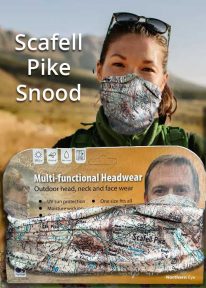
Scafell Pike - Neck Tube/Scarf/Snood
Wearable large-scale 1:25,000 Ordnance Survey map artwork: Scafell Pike in the Lake District
CELEBRATE ENGLAND'S HIGHEST MOUNTAIN and one of the National Three Peaks Challenge summits with this attractive modern Ordnance Survey 1:25,000 scale mapping snood or neck warmer. It looks great and will keep you snug and comfortable on the way up and down. The perfect gift or souvenir for everyone who climbs - or is about to climb - this iconic peak. Note: While the Ordnance Survey mapping used on the snood is up-to-date at the time of production, it is not recommended for navigation. Walkers should carry the correct OS online or sheet map and compass.Ordnance Survey Licence No.: 0100047867
-
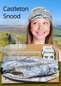
Peak District: Castleton - Neck Gaiter/Scarf/Snood
Wearable large-scale 1:25,000 Ordnance Survey map artwork: Castleton in the Peak District
CASTLETON AND THE GREAT RIDGE LIE AT THE HEART OF THE PEAK DISTRICT. This attractive, silky smooth snood features historic coloured map artwork showing the area in detail. The perfect souvenir or gift. Note: While the Ordnance Survey mapping used on the snood is up-to-date at the time of production, it is not recommended for navigation. Walkers should carry the correct OS online or sheet map and compass.Ordnance Survey Licence No.: 0100047867
-
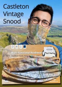
Peak District: Castleton (Vintage) - Neck Gaiter/Scarf/Snood
Wearable large-scale historic map artwork: Castleton in the Peak District
CASTLETON AND THE GREAT RIDGE LIE AT THE HEART OF THE PEAK DISTRICT NATIONAL PARK. The ever-popular town lies between the gentle limestone 'White Peak' to the south, and the starker gritstone 'Dark Peak' to the north. This attractive, silky smooth snood features historic coloured map artwork showing the area in detail. Note: The historic mapping used on this snood is not recommended for navigation. Walkers should carry the correct modern OS online or sheet map and compass. -
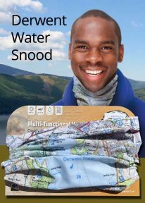
Lake District: Derwentwater - Neck Gaiter/Scarf/Snood
Wearable large-scale 1:25,000 Ordnance Survey map artwork: Derwentwater in the Lake District
DERWENT WATER IS ONE OF THE LAKE DISTRICT'S MOST POPULAR LAKES. Surrounded by fells, the island-dotted lake is three miles long and lies just to the south of Keswick. This luxurious, silky neck tube features wearable large-scale 1:25,000 Ordnance Survey map artwork of the lake and its beautiful shore. Now you or a friend can own this stylish and permanent souvenir of an iconic part of the English Lakes. Note: While the Ordnance Survey mapping used on the snood is up-to-date at the time of production, it is not recommended for navigation. Walkers should carry the correct OS online or sheet map and compass.Ordnance Survey Licence No.: 0100047867
-
Coming Soon
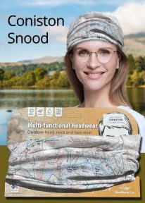
Lake District: Coniston - Neck Gaiter/Scarf/Snood
Wearable large-scale 1:25,000 Ordnance Survey map artwork: Coniston in the Lake District
CONISTON IS ONE OF THE LAKE DISTRICT'S LOVELIEST LAKES. Over five miles long and surrounded by the Cumbrian fells, Coniston is a justified favourite with visitors. The luxurious, silky neck tube features wearable large-scale 1:25,000 Ordnance Survey map artwork. Now you or a friend can own this stylish and permanent souvenir of an iconic part of the English Lake District. Note: While the Ordnance Survey mapping used on the snood is up-to-date at the time of production, it is not recommended for navigation. Walkers should carry the correct OS online or sheet map and compass.Ordnance Survey Licence No.: 0100047867
-
Coming Soon
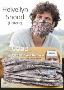
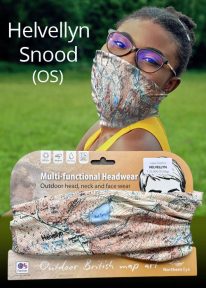
Helvellyn - Neck Gaiter/Scarf/Snood
Wearable large-scale historic map artwork: Helvellyn in the Lake District
HELVELLYN HAS BEEN A POPULAR CUMBRIAN SUMMIT FOR MANY YEARS. The snood's tightly woven material features a detailed historic colour map dating from 1912 — and shows the mountain in all its timeless beauty. A wonderful keepsake, gift or souvenir Note: The historic mapping used on this snood is not recommended for navigation. Walkers should carry the correct modern OS online or sheet map and compass. -
Helvellyn - Neck Gaiter/Scarf/Snood
Wearable large-scale 1:25,000 Ordnance Survey map artwork: Helvellyn in the Lake District
HELVELLYN IS ONE OF THE LAKE DISTRICT'S MOST POPULAR PEAKS at 950 metres / 3,118 feet above sea level. The luxurious, silky neck tube features wearable large-scale 1:25,000 Ordnance Survey map artwork. Now you or a friend can own this stylish and permanent souvenir of an iconic mountain. Note: While the Ordnance Survey mapping used on the snood is up-to-date at the time of production, it is not recommended for navigation. Walkers should carry the correct OS online or sheet map and compass.Ordnance Survey Licence No.: 0100047867
-
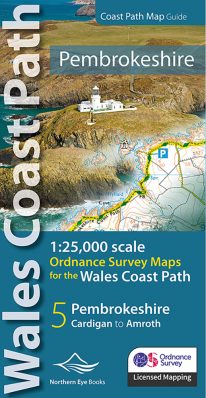 Enhanced, large scale (1: 25,000) Ordnance Survey mapping in a handy atlas format with all the mapping you need to walk a complete Pembrokeshire coast section of the Wales Coast Path. Continuous OS mapping covering the complete route from St Dogmael's near Cardigan to Amroth, on the Carmarthenshire border. Contains generous coastal extracts from large-scale OS Explorer maps OL 35 and OL36. The Pembrokeshire Coast Ordnance Survey mapping book is part of a series of map atlases covering the whole of the 870-mile long Wales Coast Path. The enhanced OS 1:25,000 maps are accurate, up-to-date and reliable. Additional map symbols show tea shops, cafes, extra parking, and public toilets. A brief introduction to the Pembrokeshire Coast includes a fascinating photo mosaic highlighting notable views, places of interest and wildlife you'll meet along the way. There is also a section of detailed Useful Information at the back of the atlas. Laminated flapped covers showing Wales Coast Path signs and waymarkers, route details and map symbols make these atlases simple and easy to use. The map books’ dimensions are 215mm x 107mm and they fit easily into a standard map pocket.
- Large scale Ordnance Survey Explorer mapping for the complete North Wales Coast in a handy atlas format.
- Highlighted official route of the Wales Coast Path.
- On-map symbols showing amenities at main towns and villages.
- Introduction with attractive photo mosaic.
- Additional useful information
-
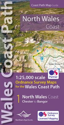 Enhanced, large scale (1: 25,000) Ordnance Survey mapping in a handy atlas format with all the mapping you need to walk a complete North Wales Coast section of the Wales Coast Path. Continuous OS mapping covering the complete route from Chester to Bangor, on the Menai Strait. Contains generous coastal extracts from large-scale OS Explorer maps 266, 265, 264 and OL17. The North Wales Coast Ordnance Survey mapping book is part of a series of map atlases covering the whole of the 870-mile long Wales Coast Path. The enhanced OS 1:25,000 maps are accurate, up-to-date and reliable. Additional map symbols show tea shops, cafes, extra parking, and public toilets. A brief introduction to the North Wales Coast includes a fascinating photo mosaic highlighting notable views, places of interest and wildlife you'll meet along the way. There is also a section of detailed Useful Information at the back of the atlas. Laminated flapped covers showing Wales Coast Path signs and waymarkers, route details and map symbols make these atlases simple and easy to use. The map books’ dimensions are 215mm x 107mm and they fit easily into a standard map pocket.
- Large scale Ordnance Survey Explorer mapping for the complete North Wales Coast in a handy atlas format.
- Highlighted official route of the Wales Coast Path.
- On-map symbols showing amenities at main towns and villages.
- Introduction with attractive photo mosaic.
- Additional useful information
-
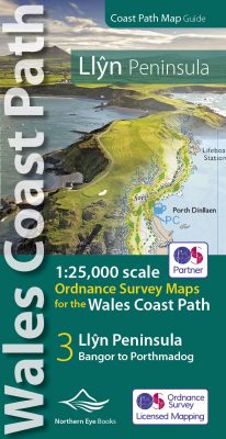 Enhanced, large scale (1: 25,000) Ordnance Survey mapping in a handy atlas format with all the mapping you need to walk a complete circuit of the Anglesey section of the Wales Coast Path. Continuous OS mapping covering the complete route from Bangor to Porthmadog. Contains coastal extracts from large scale Explorer maps 253 and 254. The Llyn Peninsula Ordnance Survey mapping book is part of a series of map atlases covering the whole of the 870-mile long Wales Coast Path. The enhanced OS 1:25,000 maps are accurate, up-to-date and reliable. Additional map symbols show tea shops, cafes, extra parking, and public toilets. A brief introduction to the Llyn Peninsula includes a fascinating photo mosaic highlighting notable views, places of interest and wildlife you'll meet along the way. There is also a section of detailed Useful Information at the back of the atlas. Laminated flapped covers showing Wales Coast Path signs and waymarkers, route details and map symbols make these atlases simple and easy to use. The map books’ dimensions are 215mm x 107mm and they fit easily into a standard map pocket.
- Large scale Ordnance Survey Explorer mapping for the complete coast of the Llyn Peninsula in a handy atlas format.
- Highlighted official route of the Wales Coast Path.
- On-map symbols showing amenities at main towns and villages.
- Introduction with attractive photo mosaic.
- Additional useful information
-
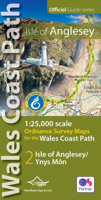 Enhanced, large scale (1: 25,000) Ordnance Survey mapping in a handy atlas format with all the mapping you need to walk a complete circuit of the Anglesey section of the Wales Coast Path. Continuous OS mapping covering the complete circuit from Menai Bridge. Contains coastal extracts from large scale Explorer maps 262 and 263. The Isle of Anglesey/Ynys Mon Ordnance Survey mapping book is part of a series of map atlases covering the whole of the 870-mile long Wales Coast Path. The enhanced OS 1:25,000 maps are accurate, up-to-date and reliable. Additional map symbols show tea shops, cafes, extra parking, and public toilets. A brief introduction to Anglesey includes a fascinating photo mosaic highlighting notable views, places of interest and wildlife you'll meet along the way. There is also a section of detailed Useful Information at the back of the atlas. Laminated flapped covers showing Wales Coast Path signs and waymarkers, route details and map symbols make these atlases simple and easy to use. The map books’ dimensions are 215mm x 107mm and they fit easily into a standard map pocket.
- Large scale Ordnance Survey Explorer mapping for the complete coast of the Isle of Anglesey/Ynys Mon in a handy atlas format.
- Highlighted official route of the Wales Coast Path.
- On-map symbols showing amenities at main towns and villages.
- Introduction with attractive photo mosaic.
- Additional useful information
-
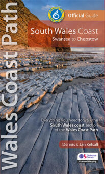 One of seven Official Guides to the Wales Coast Path The 115 mile/185km long South Wales Coast section of the Wales Coast Path runs through unexpectedly varied and dramatic coastal scenery. Along the way are four National Nature Reserves and some 14 miles of designated Heritage Coast, while the deserted salt marshes and mudflats bordering the later stages of the route alongside the mouth of the River Severn are a bird-watchers' paradise. This Official Guide splits the route into nine achievable day sections, each of about 10-17 miles / 16-27 kilometres. It contains everything local and long-distance walkers need to enjoy the path.
 -
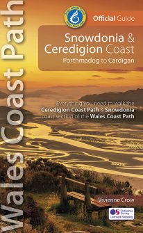 NEW, updated and revised edition – 2022 One of seven Official Guides to the Wales Coast Path The Snowdonia & Ceredigion coast offers a tremendous variety of landscape to those who walk its entire 132 miles/213 kilometres: from high, airy cliff-tops to secluded coves; from estuarine salt marshes to beaches backed by tremendous dune systems that stretch on for miles. And with that diversity comes a huge range of wildlife, including seabirds, choughs, dolphins and rare wildflowers. The history too changes with every twist and turn of this fascinating route: visitors should always be prepared for the unexpected in a region that contains the ruins of once mighty castles and has links with characters as disparate as King Arthur and members of the rock band Led Zeppelin.