-
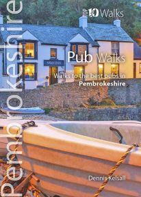 This attractive and good looking book will take you on ten short circular walks to some of the finest and most iconic pubs and inns in Pembrokeshire, in South Wales. Ever since rambling became a recognised pastime, country pubs have been magnets for walkers. Whether a lunchtime stop along the way or a final destination for the day, the promise of a thirst-quenching pint, bar snack or a hearty meal is for many, an integral part of the day. Many of Pembrokeshire's coastal inns have origins in serving seafarers, while those inland lay beside routes to and from the coast or beside old droves along which livestock were herded to market. Today, all have a fine tradition of serving visitors who come for no other purpose than to enjoy the magnificent countryside. Those chosen here have long established reputations for their food or ale and have an individual quirkiness worth seeking out.
 -
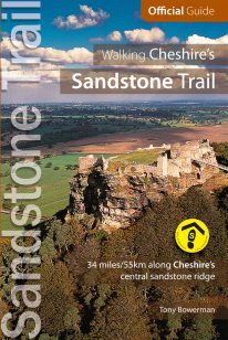 New, revised edition of the official guide to Cheshire’s Sandstone Trail – probably the most popular middle-distance walk in Northwest England. The Trail runs for 55 kilometres/34 miles along Cheshire’s beautiful and varied central sandstone ridge between Frodsham, on the Mersey Estuary in the north, and Whitchurch, just over the border in Shropshire, in the south. Along the way you'll pass two castles, some amazing views, black-and-white country pubs, a vast ancient forest, canals and pretty rural villages. Plus plenty of wildlife. What more could you want? Compiled and tested by seasoned walkers and local experts, this comprehensive, full colour guide is the perfect companion for weekend strollers and dedicated long-distance walkers alike.
 -
Coming Soon
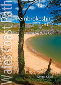 This lovely little book explores the ten best short circular walks along the southern part of the Pembrokeshire coast — itself part of the Wales Coast Path. The Pembrokeshire coast alters subtly from north to south. The southern rocks are far younger and the coast tends to be south-facing, too, creating a gentler hinterland. This influenced historical development and culture, for although the Norman advance extended throughout Pembrokeshire, settlement focused on the more fertile southern corner. It became known as ‘Little England’, with English rather than Welsh spoken, a tradition reflected in place names. Before reliable roads, trade and prosperity favoured the coast, and because the railways came late here, Pembrokeshire was largely ignored by the Industrial Revolution. Unspoiled and breathtakingly scenic, the coast is captivating every step of the way.
 -
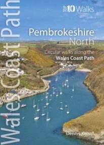 This photogenic book will take you on ten short circular walks along the northern part of the Pembrokeshire section of the Wales Coast Path. Pembrokeshire’s north coast has a rugged and remote quality, reflecting the wildness of the hills that rise behind. It was largely ignored during the Norman colonisation and even today beyond St Dogmael’s there are only a handful of coastal communities. Yet burial cairns, promontory forts and a pre-historic trackway across the Preseli Hills indicate widespread prehistoric settlement, and it was an important focus during the spread of Celtic Christianity. Fishing, farming and stock grazing were traditional ways of life, but the Industrial Revolution briefly opened coastal quarrying and the railway made Fishguard an important Irish port. Today, it is a relative backwater but the coast has an untamed beauty, its flowers, birds, seals and porpoises making it a truly special place.
 -
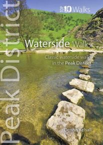 This pocket size book explores the ten best short circular waterside walks in the Peak District. Some follow lovely stretches of rivers; others explore the northern reservoirs. Several major rivers originate in the Peak, fed by countless springs, brooks and streams that have cut deep cloughs and gorges through the grit and limestone. Many powered the early industrialisation of the area while the valleys often served as conduits for trans-Pennine trade. Other dales, too steep or narrow for settlement or farming, or whose streams found subterranean courses, were ignored and today provide valuable wildlife habitats. And although the region has no significant natural lakes, reservoirs abound and are now largely naturalised within the landscape.
 -
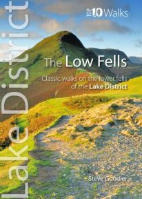 This superb pocket size book will take you on ten short circular walks to the ten best-known low fells in the Lake District The fells get their name from the Old Norse word, fjalls, which originally meant areas of rough upland grazing. Today, the Lakeland fells promise some of the best high level walking in England, and a real sense of freedom. But though the high fells often feature rocky summits, narrow edges and sheer cliffs, the lower fells, below the 2,000 foot contour, are greener, rounder and kinder. Walking on them can still be steep and strenuous, of course, but the routes are more suitable for the general walker. And the views are just as incredible.
 -
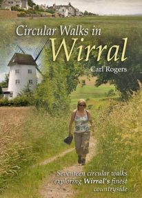 Circular Walks in Wirral will take you to some of Wirral’s most peaceful and scenic corners, and outlines 17 walks exploring Wirral's finest countryside spread throughout the peninsula.
 -
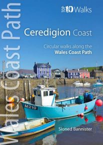 This handy pocket size book will take you on ten of the best short circular walks along the Ceredigion coast. Cardigan Bay embraces the dramatic sweep of the Welsh coastline, from Bardsey Island on the tip of the Llŷn in the north, to Strumble Head in Pembrokeshire in the south. It takes in parts of two National Parks: Snowdonia and Pembrokeshire, and three different counties: Gwynedd, Ceredigion and Pembrokeshire. The southern half of Cardigan Bay covers the rugged coastline between Aberystwyth and Cardigan. The dramatic cliffs and hidden coves are part of the Ceredigion Coast Path: a 60 mile trail that promises stunning views and some of the best opportunities for walkers to spot maritime wildlife in Wales.
 -
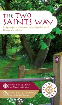 An impressive guide book that coincides with the growing interest in pilgrimage as an aspect of ‘wellness’ tourism that benefits body, mind and spirit. The guide is packed with information both practical and historical. It is an attractive publication with OS map extracts and numerous high quality colour photos. The Two Saints Way has a symmetrical structure with the two cathedrals at either end, Stoke Minster in the middle and two churches dedicated to St Mary at the quarter points. With this in mind, the 92 mile route is divided into four colour coded sections - 1: Chester to Nantwich, 2: Nantwich to Stoke, 3: Stoke to Stafford and 4: Stafford to Lichfield. Each section is further divided into four stages of between 3.5 and 8.5 miles in length. The route is described in both directions. Highlights on this varied route include Beeston Castle, Englelsea Brook Chapel and Museum, the Staffordshire Hoard at the Potteries Museum, Trentham Gardens and Cannock Chase Area of outstanding Natural Beauty. The guide contains a wealth of fascinating information on many features of interest.
 -
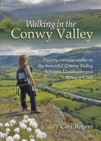 Twenty circular walks between Llandudno and Betws-y-Coed, in and around the beautiful Conwy Valley in eastern Snowdonia.
 -
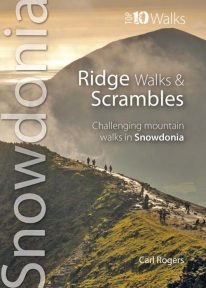 The ten routes outlined in this attractive pocket size book are amongst the very best challenging routes on the mountains of Snowdonia. Snowdonia's mountain ridges can be every bit as dramatic as the summits they connect. Some are well known classics like the Snowdon Horseshoe or Nantlle Ridge, while others are surprisingly well kept secrets like the Llech Du Spur, Gyrn Lâs Ridge or the ridges of the northern Glyderau. Created as a companion volume to the best selling 'Top 10 Mountain Walks', these little books will show you the very best that Snowdonia has to offer.
 -
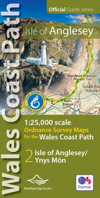 Enhanced, large scale (1: 25,000) Ordnance Survey mapping in a handy atlas format with all the mapping you need to walk a complete circuit of the Anglesey section of the Wales Coast Path. Continuous OS mapping covering the complete circuit from Menai Bridge. Contains coastal extracts from large scale Explorer maps 262 and 263. The Isle of Anglesey/Ynys Mon Ordnance Survey mapping book is part of a series of map atlases covering the whole of the 870-mile long Wales Coast Path. The enhanced OS 1:25,000 maps are accurate, up-to-date and reliable. Additional map symbols show tea shops, cafes, extra parking, and public toilets. A brief introduction to Anglesey includes a fascinating photo mosaic highlighting notable views, places of interest and wildlife you'll meet along the way. There is also a section of detailed Useful Information at the back of the atlas. Laminated flapped covers showing Wales Coast Path signs and waymarkers, route details and map symbols make these atlases simple and easy to use. The map books’ dimensions are 215mm x 107mm and they fit easily into a standard map pocket.
- Large scale Ordnance Survey Explorer mapping for the complete coast of the Isle of Anglesey/Ynys Mon in a handy atlas format.
- Highlighted official route of the Wales Coast Path.
- On-map symbols showing amenities at main towns and villages.
- Introduction with attractive photo mosaic.
- Additional useful information