-
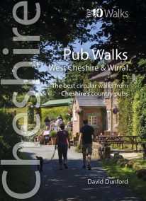 This handy, wonderfully illustrated little guidebook gives walkers the ten best short circular walks to some of the very best country pubs and inns in Cheshire and Wirral in a handy, pocketable format. As befits a well-heeled, fertile county with a rich farming heritage, the country pubs and inns of Cheshire and Wirral are hugely rewarding to visitors and walkers. From numerous candidates we’ve whittled the list down to personal favourites that balance a lack of pretention with good service, and are also blessed with pleasant locations and rewarding walks from the doorstep, while attempting a representative geographical distribution covering the range of landscapes of this diverse county.
 -
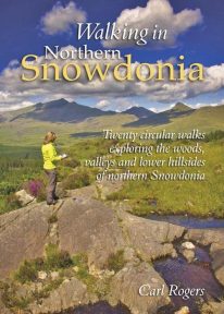 This attractive book explores twenty of the best low level circular walks in northern Snowdonia. Walking in Northern Snowdonia is dedicated to the northern half of the National Park, bounded by the Conwy Valley to the east, Glyn Lledr and the Vale of Ffestiniog to the south and Cwm Pennant to the west. Twenty circular walks are described, ranging in length from 4½ to 9 miles, which explore the woods, valleys and lower hillsides of this unique and beautiful area.
 -
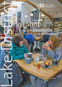 A visit to a tea shop adds something special to a walk. It’s always a treat to sit down to coffee and cake at the end of an afternoon stroll or to tuck into a hearty lunch half-way through a gorgeous hike. From quaint little tea rooms that still serve drinks in china cups to modern cafés staffed by trained baristas, the Lake District has plenty to offer — and all surrounded by a truly breathtaking UNESCO World Heritage landscape. The ten tea shops in this book have been chosen partly on the basis of the excellent walking that can be enjoyed from their doors, and partly on the basis of the fare and ambience they have to offer. They occupy village, lakeside and woodland locations. The walks themselves take in hidden valleys, low fells, lakes, waterfalls, riverside paths, fabulous viewpoints and wildflower-filled woods — a tremendous array of the sort of scenery for which the Lake District has become world famous.
 -
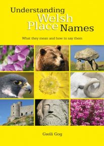 Puzzled by Welsh place names but want to know what they mean and how to say them? This fascinating, easy-to-use guide means non-Welsh speakers can now easily translate and understand place names all over Wales — on the map, on road signs, and out in the countryside. Armed with this insider knowledge, you’ll discover there’s a whole exciting new dimension to the Welsh landscape. In fact, Wales will never be quite the same again ….
 -
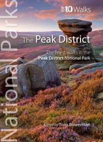
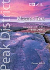 This lovely, pocket size book offers the ten best short circular walks to upland moors and tors across the Peak District. The uplands of the Peak bear the characteristics of hills rather than mountains: high, undulating plateaux dissected by deep, meandering valleys. Yet there is little uniformity; the seemingly remote moorland of the Kinder plateau is in sharp contrast to the gentler and lower upland heaths found farther south. These landscapes change subtly with the seasons and, for those who care to look, are rich in wildlife. There are birds, hares, and foxes; and in summer, adders and lizards bask in the sun while butterflies dance in the remotest places.
 -
 One of a series of four books for Snowdonia in the popular Top 10 Walks series. Handy, pocket-sized, full colour walking guides written by experts. The perfect impulse buy. Free display stands available. Other titles in the series include: Mountain Walks, Ridge Walks & Scrambles and Pub Walks. Uses Ordnance Survey mapping.
 -
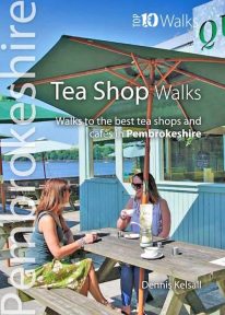 Pembrokeshire’s Café Culture is booming and it’s not the big chains leading the way. Gone are the steamy fugs, greasy-spoon menus and chipped mugs; instead, there’s no shortage of bright and friendly venues serving speciality coffees and teas, home-made baking, and wonderful snacks and meals that capitalise on the best of local produce and culinary talent. Very often there’re take-away options too and sometimes interesting wines or Welsh-brewed beers and ciders. Many are open all day from breakfast and morning coffee to afternoon tea, with some venues running into the evening too with live music, poetry or storytelling. They’re great places to rest or meet up with friends, too; so go for a walk and see what you can find — you’ll not be disappointed.
 -
Minehead to Bude
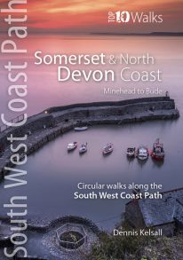
The ten walking routes featured here highlight the best short circular walks along the Somerset and North Devon Coast section of the popular, 630-mile long South West Coast Path (SWCP). Exmoor's fringe of majestic cliffs, secluded coves, ragged wave-washed rocks and rich coastal woodland is a stunning prelude to the long distance trail. Further west are Devon's glorious beaches but also an ever-more rugged coastline, which curves to the battering Atlantic surf. Large settlements are few, but occasional picturesque hamlets and villages grew around coves and small landings where fishing and seaborne trade (not always above board) supplemented the traditional farming way of life of the hinterland. Nature complements the intrinsic beauty of this landscape; seabirds abound on the cliffs and shore, while the lush and sometimes rare flora of unspoiled cliffs, native woodland, rough pasture and dunes supports smaller birds and countless butterflies. The five-book series of 'Top Ten Walks' covers the whole of the UK's famous South West Coast Path. Each book explores the highlights along the way; showcasing its natural beauty, wildlife and heritage. Once you've experienced what the Somerset and North Devon section has to offer, we think you'll be inspired to come back to tackle the complete trail. -
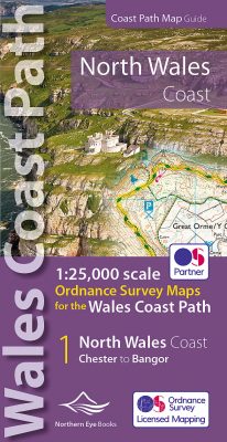 Enhanced, large scale (1: 25,000) Ordnance Survey mapping in a handy atlas format with all the mapping you need to walk a complete North Wales Coast section of the Wales Coast Path. Continuous OS mapping covering the complete route from Chester to Bangor, on the Menai Strait. Contains generous coastal extracts from large-scale OS Explorer maps 266, 265, 264 and OL17. The North Wales Coast Ordnance Survey mapping book is part of a series of map atlases covering the whole of the 870-mile long Wales Coast Path. The enhanced OS 1:25,000 maps are accurate, up-to-date and reliable. Additional map symbols show tea shops, cafes, extra parking, and public toilets. A brief introduction to the North Wales Coast includes a fascinating photo mosaic highlighting notable views, places of interest and wildlife you'll meet along the way. There is also a section of detailed Useful Information at the back of the atlas. Laminated flapped covers showing Wales Coast Path signs and waymarkers, route details and map symbols make these atlases simple and easy to use. The map books’ dimensions are 215mm x 107mm and they fit easily into a standard map pocket.
- Large scale Ordnance Survey Explorer mapping for the complete North Wales Coast in a handy atlas format.
- Highlighted official route of the Wales Coast Path.
- On-map symbols showing amenities at main towns and villages.
- Introduction with attractive photo mosaic.
- Additional useful information
-
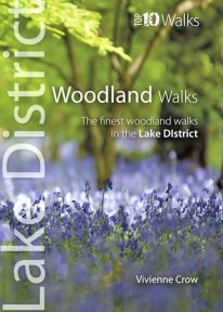 This lovely little book will take you on ten short circular walks through the finest woods and forests in the Lake District People seem to be drawn to trees, be they part of a landscape that has existed for centuries or planted in more modern times. There is something special about being in among their sturdy trunks, surrounded by a rich understorey with the sunlight piercing the canopy high above. In the Lake District, there is a huge variety of woodland — and no matter what their origins, what tree types grow there or how they have been managed, that extraordinary atmosphere never fails to nourish the soul.
 -
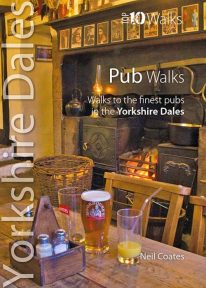 This lovely little book will take you on short circular walks to some of the Yorkshire Dales' most distinctive pubs and inns. The pubs of the Yorkshire Dales reflect both the area and the local people: occasionally gritty and challenging, sometimes uncompromising but essentially hugely welcoming and full of character. Some of England’s best watering holes stand here beside country lanes and village greens as they have for centuries past, gathering and exuding that unique amalgam which defines a pub. The flagged floors, the winter fires, the lamplight pooling onto lanes through bottle-glass windows, the quirky bars; that happy jigsaw of time and place which makes rambling to and between them one of life’s great pleasures.
 -
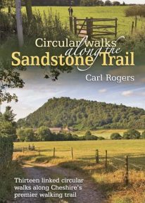
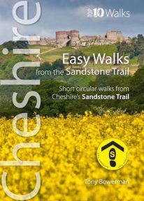 Cheshire’s Sandstone Trail is probably the most popular middle-distance walk in Northwest England. The Trail runs for 55 kilometres/34 miles along Cheshire’s beautiful and varied central sandstone ridge between Frodsham and Whitchurch, just over the border in Shropshire. This cleverly structured and well designed guidebook gives walkers the ten best short circular walks along the length of the Sandstone Trail in a handy, pocketable format.
 -
 Discover the very best of the Peak District. These ten themed walks explore the contrasting faces of the Peaks — the gentle White and rugged Dark Peak. Discover clear rivers and streams, ancient packhorse bridges and stepping stones. Walk through winding dales and valleys bright with wildflowers. Visit stately Chatsworth or marvel at the panorama from Monsal Head. Tour upland reservoirs and dramatic rocky edges popular with climbers. Slog up Shutlingsloe or explore the open moorland and strangely eroded tors on Kinder Edge. Every one is a walk to remember.
 -
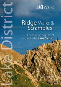 The Lakeland Fells have some of the finest ridge walks in the country. Exploring these ridges offers fell walking at its most satisfying — staying high, taking in several summits and enjoying the spectacular settings. Many of the Lake District’s ridge walks have become classics, like the grassy edges of the Fairfield and Kentmere Horseshoes, or rocky aretes of Striding Edge and Swirral Edge and the aptly named Sharp Edge of Blencathra.
 -
 Product Description One of nine books in the new Top 10 Walks: Wales Coast Path series. This attractive and cleverly structured guidebook gives walkers the ten best walks on the southern part of the South Wales Coast section of the Wales Coast Path, in a popular pocketable format. With clear information, an overview and introduction for each walk, expertly written numbered directions, Ordnance Survey maps, superb, eye-grabbing panoramic photographs, and interpretation of points of interest along the way, these guides set a new standard in clarity, appeal and ease-of-use. Contents The Wales Coast Path: an introduction Top Ten Walks: Wales Coast Path: North Wales Coast: a photo mosaic
- Holywell & Basinwerk Abbey
- Talacre & Gronant dunes
- Prestatyn to Graig Fawr
- Rhyl to Rhuddlan Castle
- Little Orme
- Around the Great Orme
- Conwy Mountain
- Above Penmaenmawr
- Aber Falls
- Lafan Sands - low/high loop
-
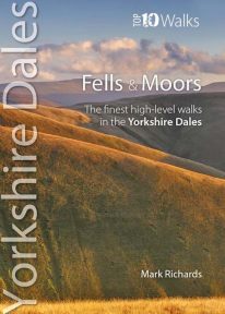 This attractive pocket size book features the ten finest short circular walks on the fells and moors of the Yorkshire Dales. The term ‘fell’ derives from the Norse settlers and was applied here to areas of upland pasture. While the Lake District is defined by its soaring ridges, the Dales, as their name implies, are an intricate pattern of valleys set in a muted moorland landscape. Yet great hills exist — to enthral and enthuse even the most ardent hillgoer. There is no better way of grasping the scale, beauty and extent of the Yorkshire Dales than from this fabulous compact of high fell tops. Each rooted in a dale, each dignified with unique prospects, all meriting walking as a richly rewarding company of hills.
 -
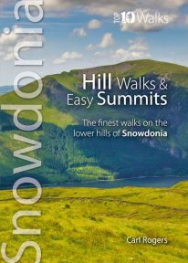
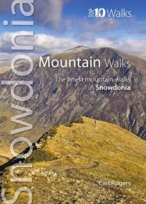 The hills and mountains of Snowdonia will captivate any lover of wild mountain scenery, with around 100 summits above 2,000 feet (approximately 610 metres) and fourteen exceeding 3,000 feet (914 metres). The ten classic walks in this great little guide have been chosen to give a variety of routes, spread across the entire National Park, with most of the main hill groups represented. For each mountain the most scenic route has been chosen and where possible these are well-established, classic paths, easy to follow, with good access and official parking. Enjoy Snowdonia.
 -
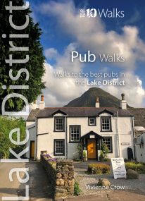 Here in one pocket size book are ten, easy, short circular walks to the finest Lake District pubs. The words ‘Lakeland’ and ‘pub’ go together like ‘bread’ and ‘butter’ or ‘Romeo’ and ‘Juliet’. The Lake District is a region that’s famed for its traditional inns and cosy, friendly village pubs almost as much as it’s famed for its magnificent walking country. So, what could be better than combining the two—enjoying a pint of local ale half-way through a gorgeous Sunday stroll, or a hearty meal at the end of a day’s hiking?
 -
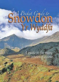 This book is a new and wholly updated edition of the popular, full-colour, handy sized guide to all of Snowdon’s recognised routes of ascent – from the six ‘Classic Paths’ to the many lesser known and less frequented routes.
 -
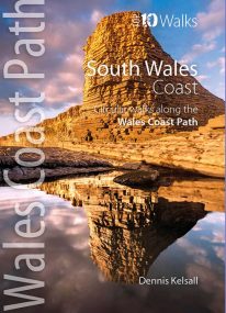 Product Description One of nine books in the new Top 10 Walks: Wales Coast Path series. The past two centuries have wrought more change on South Wales than any other section of the country’s coast. Until the end of the 18th century, Swansea, Barry and even Cardiff were just small ports, though their ships traded far and wide. The industry of iron and coal changed things forever but most of the coast and its immediate hinterland were left unspoiled and elsewhere, nature has reclaimed some of what was taken. The coast is one of extreme contrasts, ranging from great dune systems through sheer cliffs to miles of coastal saltmarsh. Nowhere is far from a delightful stretch overlooking the sea, with fine views, nature and heritage all around.
 -
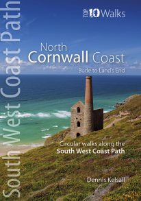
Bude to Land's End
The ten walking routes featured here highlight the best short circular walks along the North Cornwall Coast section of the popular, 630-mile long South West Coast Path (SWCP). From Bude to the western-most tip of England at Land's End, Cornwall's northern coast has a character all its own. Much of its 140 miles is set against the open Atlantic, whose winter storms and thundering waves have sculpted a rugged coastline of formidable cliffs. Tiny, wave-washed coves and zawns contrast expansive beaches and dunes, the wild scenery often spilling offshore to half submerged reefs, stacks and rocky islands. The holiday resorts of St Ives and Newquay can attract summer crowds, but elsewhere, the coast is often deserted, with only birds for company and the delights of nature as distractions. The five-book series of 'Top Ten Walks' covers the whole of the UK's famous South West Coast Path. Each book explores the highlights along the way; showcasing its natural beauty, wildlife and heritage. Once you've tasted what the North Cornwall section has to offer, we think you'll be inspired to come back to tackle the complete trail. -
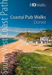
Dorset's best coastal pub walks
The excellent pubs along the Dorset coast complement the walking on this superlative stretch of the South West Coast Path. Each walk incorporates a stretch of the South West Coast Path, and starts and finishes close to a superb pub. Combined they cover the very best stretches of Dorset’s coastline, one of great natural beauty and variety. The pub walks here are also ordered from west to east, starting with Lyme Regis and finishing at Studland. All the pubs are situated either right on the coast or a short distance inland — some in coves and harbours, others right on the beach — and almost every one is open all day. With the pubs open all year and the walking good in all seasons, Dorset’s iconic Jurassic Coast is a year-round destination. -
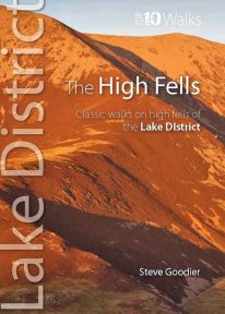 This handy, pocket size book explores ten short circular routes on the best high fells in the Lake District. The Lakeland fells have inspired writers, artists and walkers for centuries. Like the deep valleys that separate them, they were formed by the flow and grind of ancient ice sheets. Above the 2,000-foot contour, they form a high mountain environment whose sheer cliffs, narrow edges, and exposed rocky summits demand respect. Today, this rugged upland landscape is one of the most visited hill walking areas in Britain. The high fells feature enough classic routes, challenges and captivating views to delight even the most demanding fell walker.
 -
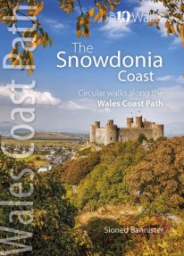 This lovely little book contains the ten best short circular walks along the north part of the Cardigan Bay section of the Wales Coast Path Cardigan Bay embraces the dramatic sweep of the Welsh coastline, from Bardsey island on the tip of Lleyn, in the north, to Strumble Head in Pembrokeshire, in the south. It takes in parts of two National Parks: Snowdonia and Pembrokeshire, and three different counties, Gwynedd, Ceredigion and Pembrokeshire. The striking northern section between Porthmadog and Borth is as varied as it is beautiful. Characterised by vast beaches and rugged cliffs, the coast offers superb walking with ever-changing views and a wealth of wildlife.
 -
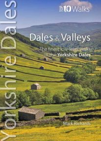 This lovely pocket size book describes the ten best short circular walks in the Yorkshire Dales' dales and valleys. The focus in the Yorkshire Dales tends to be on a trio of much-loved valleys: Swaledale, Wensleydale and Wharfedale. Yet, broadening the gaze, one finds other equally spellbinding valleys, such as Airedale, Ribblesdale, the Rawthey and Dentdale. To the north, the bounding valleys of the Eden and Lune stretch the beauty of the National Park into wider horizons of pastoral serenity. Here are walks for quiet enjoyment and seasonal beauty, where nature still reigns amid traditional patterns of farming practice. Solid stone barns and field walls characterise the dale bottoms; and the flora of the dales is wonderfully diverse: many a meadow retains its native herbal mix — yielding a delightful aroma at haytime.
 -
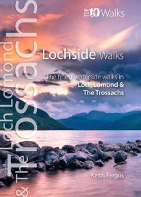 The ten best circular walks exploring the area’s seawater and freshwater lochs and lochans, including lochs Lomond, Katrine, and Venachar. Stunning scenery and unusual wildlife. Featured walks include: Luss, Balloch Castle Country Park, Loch Lomond NNR, Balmaha & Milarrochy, Sallochy Wood & Dun Maoil, Along Loch Katrine, Loch Ard, Loch Katrine & Loch Arklet, Inversnaid & Loch Lomond and Loch Venachar.
 -
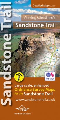
Large-scale Ordnance Survey maps for walking Cheshire's Sandstone Trail in a handy pocket size book.
Cheshire’s Sandstone Trail is probably the most popular middle-distance walk in Northwest England. Here, in handy, pocket size book format are all the maps you need to walk Cheshire's entire 55 kilometre/34 mile Trail.- Enlarged and enhanced, large scale 1:25,000 Ordnance Survey mapping for the whole Sandstone Trail
- Up-to-date route of Sandstone Trail clearly highlighted in yellow
- Extra map symbols for pubs, tea rooms, parking and more
- Trail introduction and photo mosaic
- Useful information section
- Ideal for walkers and all outdoor enthusiasts along Cheshire's sandstone ridge
- Contains relevant mapping from two OS maps for the price of one
-
 A popular classic Cheshire walking book. The Sandstone Trail runs for 34 miles/55 km along Cheshire’s wooded central sandstone ridge, and is one of Northwest England’s best-known and most popular walking routes.
 -
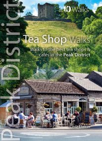 The Peak District abounds with cafes and tea shops offering fabulous, freshly brewed coffee and a mouthwatering variety of speciality teas. This pocket-size guide picks carefully selected cafés across the Peak District — in locations ranging from former stations to community cafés, National Trust properties to hillside farms, and bakeries on town streets to tearooms tucked down alleyways. All of them offer a great choice of often home-baked or locally sourced produce, and a pleasant place to relax after a refreshing walk. This handy pocket size book will take you on short circular walks to the ten friendliest and most fantastic cafes and tea shops in the Peak District.
 -
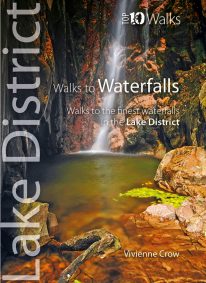 WINNER OF THE OUTDOOR WRITERS AND PHOTOGRAPHERS’ GUILD’S ‘BEST GUIDEBOOK’ AWARD 2013 This attractive pocket size book features ten easy, short circular walks to the most amazing Lake District waterfalls. The dramatic waterfalls of the Lake District are mostly a by-product of the last Ice Age — the awesome result of the ancient interplay of ice and rock. Given perpetual life by the region’s high rainfall, they come thundering down from the fells in a variety of forms. No two are the same. Many carry the name ‘force’—from the old Norse foss simply meaning ‘waterfall’—a remnant of the times when Norsemen dominated these uplands. Unmissable!
 -
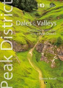 This attractive pocket size book gives you the ten very best dale and valley walks in the Peak District. The White Peak is known for dramatic limestone gorges: convoluted pathways carved into its heart, where rearing pinnacles, dark caves and thundering rivers struck awe into seventeenth-century travellers. Still captivating today, they harbour rich woodland, wildflower meadows and disappearing and resurgent streams, one of the area’s strangest curiosities. Delightful Dovedale, once the haunt of the renowned anglers Izaak Walton and Charles Cotton, contrasts with Cave Dale, a gaunt, dry passage below Castleton’s Norman stronghold. But the Dark Peak has attractive valleys too, and different again is the Dane Valley, which cuts onto the Cheshire Plain from the gritstone moors.
 -
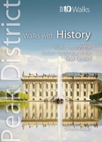 This lovely pocket size book explores ten of the Peak District's most fascinating historic landscapes — from prehistoric monuments to Industrial Revolution ruins. Stone tools from Thor’s Cave indicate that man arrived in the Peak as the glaciers receded. More obvious are Bronze and Iron Age circles, burials and earthworks, as well as the scars of mineral extraction — begun by the Romans and continuing today. Some Peakland churches claim Saxon foundation, and by the Middle Ages there was an extensive network of tracks and settlements. Water powered the first industrial revolution, bringing roads, canals and railways, and in the fine country mansions, farmsteads, cottages and town houses there is a rich variety of vernacular and classic architecture.
 -
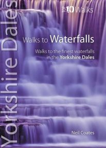 This pretty little book gives you short circular walks to the most spectacular waterfalls in the Yorkshire Dales. Geology and the way it shapes the land have created a countryside tailor-made for the development of waterfalls. The gritstone fells and moors gather copious rainfall, which they shed along countless becks and rivers that erode the rock into twisting gills and valleys. Where localised geological conditions bring together the grits and limestones, differential erosion creates bands of resistant rocks over which the becks plunge as hidden cataracts and waterfalls, often called forces in the Yorkshire Dales. Each has its own unique form and atmosphere to discover and explore.
 -
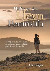 Walks on the Lleyn Peninsula contains 16 circular walks which explore some of the finest sectoins of the coast, along with several of lleyn’s shapely hills. With distances ranging from 1.5 – 7.25 miles, all walkers are catered for – from those looking for a casual half-day walk to add colour to a hoilday, to the more ambitious who may perhaps complete two or more routes as an alternative to Snowdonia. Understandably popular.
 -
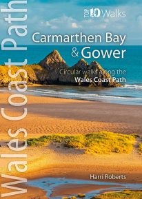 This handy, pocket size book will take you on the ten best short circular walks along the Carmarthen Bay and Gower stretch of the Wales Coast Path. Carmarthen Bay embraces an area of Welsh coast stretching from south Pembrokeshire to the Gower Peninsula. Long, sandy beaches and wide, silty estuaries dominate much of the bay, though there are also high cliffs and rocky coves in places. The Gower Peninsula, at the eastern end of the bay, is a small but priceless gem. Britain’s first official Area of Outstanding Natural Beauty (AONB), the peninsula contains an astonishing variety of landscapes: dunes, marshland, high cliffs, windswept downs, wooded valleys, picturesque villages and glorious sandy beaches — all linked by a superb footpath network.
 -
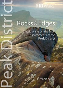 This attractive pocket size book will take you on short circular walks to the ten finest rocks and edges in the Peak District. Surprisingly for newcomers, the Peak District is almost devoid of anything resembling a traditional mountain peak (the name instead derives from the Old English paec, merely meaning ‘hill’). In reality, The Peak is a high, sloping plateau, cleft by deep valleys and winding ravines. In compensation, however, there are long runs of startlingly dramatic cliffs — here known as edges — and spectacularly weathered outcrops of rock, often referred to as tors. For rock climbers, they offer some of England’s finest challenges, while for walkers the views from the escarpments’ rims can be unforgettable.
 -
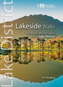 This popular pocket size book will take you on ten short circular walks to the finest lakeside paths in the Lake District. Lakeland’s characteristic lakes and meres are a legacy of the last Ice Age when vast ice sheets scoured out deep U-shaped valleys and upland combes. Today, sixteen main lakes and scores of smaller tarns punctuate the National Park. They include England’s longest lake (Windermere: 10½ miles long), and its deepest lake (Wast Water: 243 feet deep). Only Windermere, Derwent Water, Coniston Water and Ullswater have regular steamer and ferry services, yet every lake features dramatic waterside walks that will stay in your memory forever.
 -
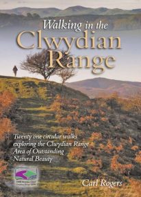 Walking in the Clwydian Range describes 21 circular walks spread throughout the AONB (Area of Outstanding Natural Beauty); many on the well known Offa’s Dyke Path, others in the little known country to the east of the main ridge. Some lovely walks.
 -
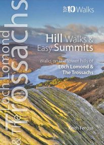 The ten best circular hill walks in the area. Classic easy summits include Conic Hill, Duncryne and Ben A’an. Perfect panoramas, breathtaking views and a wealth of wildlife.
 -
Coming Soon
 This authoritative walking guide will take you to some of the very best, tried-and-tested circular walking routes across NorthWales. The book covers walks in Anglesey, the Lleyn Peninsula, Snowdonia, the Conwy Valley, the Clwydian Range, and the Vale of Llangollen.
 -
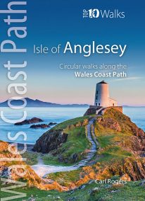 Product Description One of nine books in the new Top 10 Walks: Wales Coast Path series. The Isle of Anglesey offers some of the finest coastal walking in North Wales. In just over 125 miles there are dramatic sea cliffs, quiet coves, wide sandy bays, tiny fishing villages, modern resorts, coastal hills and remains from a rich maritime heritage. The walks in this book are what I consider to be the finest routes along this superb section of coast, one of the seven main sections of the wales Coast Path.
 -
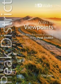 This handy pocket size book will take you on short circular walks to the ten finest views and viewpoints in the Peak District. Views are why many of us venture into the hills and countryside in the first place. Nothing beats a sweeping view from a moorland edge or hill, or an arching panorama over a pleasant valley. Sometimes it’s just the simple pleasure of the patterns of light and shade, the textures and colours of the woodland or the flowing beauty of the stream we’re walking beside. But typically there’s a feeling that you’ve earned a great view through sheer effort – even if the easiest approach had been taken to reach it. Perhaps that’s why so many of the great Peak District views are atop minor summits, at moorland edges, or overlooking deep valleys.
 -
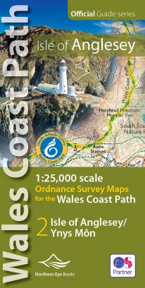 Enhanced, large scale (1: 25,000) Ordnance Survey mapping in a handy atlas format with all the mapping you need to walk a complete circuit of the Anglesey section of the Wales Coast Path. Continuous OS mapping covering the complete circuit from Menai Bridge. Contains coastal extracts from large scale Explorer maps 262 and 263. The Isle of Anglesey/Ynys Mon Ordnance Survey mapping book is part of a series of map atlases covering the whole of the 870-mile long Wales Coast Path. The enhanced OS 1:25,000 maps are accurate, up-to-date and reliable. Additional map symbols show tea shops, cafes, extra parking, and public toilets. A brief introduction to Anglesey includes a fascinating photo mosaic highlighting notable views, places of interest and wildlife you'll meet along the way. There is also a section of detailed Useful Information at the back of the atlas. Laminated flapped covers showing Wales Coast Path signs and waymarkers, route details and map symbols make these atlases simple and easy to use. The map books’ dimensions are 215mm x 107mm and they fit easily into a standard map pocket.
- Large scale Ordnance Survey Explorer mapping for the complete coast of the Isle of Anglesey/Ynys Mon in a handy atlas format.
- Highlighted official route of the Wales Coast Path.
- On-map symbols showing amenities at main towns and villages.
- Introduction with attractive photo mosaic.
- Additional useful information
-
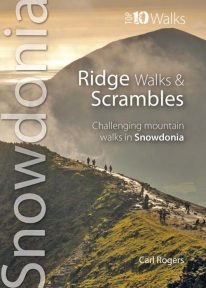 The ten routes outlined in this attractive pocket size book are amongst the very best challenging routes on the mountains of Snowdonia. Snowdonia's mountain ridges can be every bit as dramatic as the summits they connect. Some are well known classics like the Snowdon Horseshoe or Nantlle Ridge, while others are surprisingly well kept secrets like the Llech Du Spur, Gyrn Lâs Ridge or the ridges of the northern Glyderau. Created as a companion volume to the best selling 'Top 10 Mountain Walks', these little books will show you the very best that Snowdonia has to offer.
 -
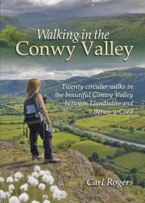 Twenty circular walks between Llandudno and Betws-y-Coed, in and around the beautiful Conwy Valley in eastern Snowdonia.
 -
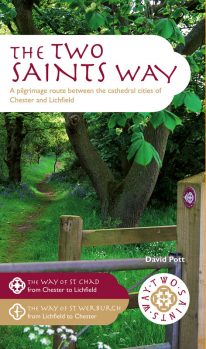 An impressive guide book that coincides with the growing interest in pilgrimage as an aspect of ‘wellness’ tourism that benefits body, mind and spirit. The guide is packed with information both practical and historical. It is an attractive publication with OS map extracts and numerous high quality colour photos. The Two Saints Way has a symmetrical structure with the two cathedrals at either end, Stoke Minster in the middle and two churches dedicated to St Mary at the quarter points. With this in mind, the 92 mile route is divided into four colour coded sections - 1: Chester to Nantwich, 2: Nantwich to Stoke, 3: Stoke to Stafford and 4: Stafford to Lichfield. Each section is further divided into four stages of between 3.5 and 8.5 miles in length. The route is described in both directions. Highlights on this varied route include Beeston Castle, Englelsea Brook Chapel and Museum, the Staffordshire Hoard at the Potteries Museum, Trentham Gardens and Cannock Chase Area of outstanding Natural Beauty. The guide contains a wealth of fascinating information on many features of interest.
 -
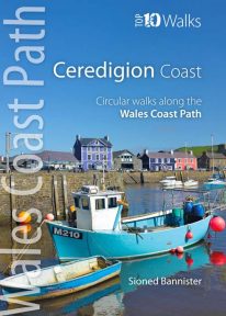 This handy pocket size book will take you on ten of the best short circular walks along the Ceredigion coast. Cardigan Bay embraces the dramatic sweep of the Welsh coastline, from Bardsey Island on the tip of the Llŷn in the north, to Strumble Head in Pembrokeshire in the south. It takes in parts of two National Parks: Snowdonia and Pembrokeshire, and three different counties: Gwynedd, Ceredigion and Pembrokeshire. The southern half of Cardigan Bay covers the rugged coastline between Aberystwyth and Cardigan. The dramatic cliffs and hidden coves are part of the Ceredigion Coast Path: a 60 mile trail that promises stunning views and some of the best opportunities for walkers to spot maritime wildlife in Wales.
 -
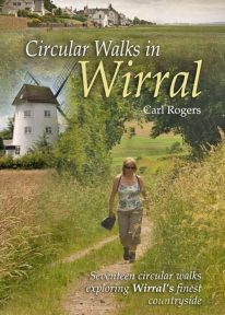 Circular Walks in Wirral will take you to some of Wirral’s most peaceful and scenic corners, and outlines 17 walks exploring Wirral's finest countryside spread throughout the peninsula.