-
 This lovely little book will take you on short circular walks to some of the Yorkshire Dales' most distinctive pubs and inns. The pubs of the Yorkshire Dales reflect both the area and the local people: occasionally gritty and challenging, sometimes uncompromising but essentially hugely welcoming and full of character. Some of England’s best watering holes stand here beside country lanes and village greens as they have for centuries past, gathering and exuding that unique amalgam which defines a pub. The flagged floors, the winter fires, the lamplight pooling onto lanes through bottle-glass windows, the quirky bars; that happy jigsaw of time and place which makes rambling to and between them one of life’s great pleasures.
 -
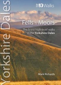 This attractive pocket size book features the ten finest short circular walks on the fells and moors of the Yorkshire Dales. The term ‘fell’ derives from the Norse settlers and was applied here to areas of upland pasture. While the Lake District is defined by its soaring ridges, the Dales, as their name implies, are an intricate pattern of valleys set in a muted moorland landscape. Yet great hills exist — to enthral and enthuse even the most ardent hillgoer. There is no better way of grasping the scale, beauty and extent of the Yorkshire Dales than from this fabulous compact of high fell tops. Each rooted in a dale, each dignified with unique prospects, all meriting walking as a richly rewarding company of hills.
 -
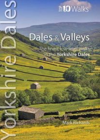 This lovely pocket size book describes the ten best short circular walks in the Yorkshire Dales' dales and valleys. The focus in the Yorkshire Dales tends to be on a trio of much-loved valleys: Swaledale, Wensleydale and Wharfedale. Yet, broadening the gaze, one finds other equally spellbinding valleys, such as Airedale, Ribblesdale, the Rawthey and Dentdale. To the north, the bounding valleys of the Eden and Lune stretch the beauty of the National Park into wider horizons of pastoral serenity. Here are walks for quiet enjoyment and seasonal beauty, where nature still reigns amid traditional patterns of farming practice. Solid stone barns and field walls characterise the dale bottoms; and the flora of the dales is wonderfully diverse: many a meadow retains its native herbal mix — yielding a delightful aroma at haytime.
 -
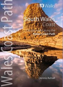 Product Description One of nine books in the new Top 10 Walks: Wales Coast Path series. The past two centuries have wrought more change on South Wales than any other section of the country’s coast. Until the end of the 18th century, Swansea, Barry and even Cardiff were just small ports, though their ships traded far and wide. The industry of iron and coal changed things forever but most of the coast and its immediate hinterland were left unspoiled and elsewhere, nature has reclaimed some of what was taken. The coast is one of extreme contrasts, ranging from great dune systems through sheer cliffs to miles of coastal saltmarsh. Nowhere is far from a delightful stretch overlooking the sea, with fine views, nature and heritage all around.
 -
 This lovely little book contains the ten best short circular walks along the north part of the Cardigan Bay section of the Wales Coast Path Cardigan Bay embraces the dramatic sweep of the Welsh coastline, from Bardsey island on the tip of Lleyn, in the north, to Strumble Head in Pembrokeshire, in the south. It takes in parts of two National Parks: Snowdonia and Pembrokeshire, and three different counties, Gwynedd, Ceredigion and Pembrokeshire. The striking northern section between Porthmadog and Borth is as varied as it is beautiful. Characterised by vast beaches and rugged cliffs, the coast offers superb walking with ever-changing views and a wealth of wildlife.
 -
Coming Soon
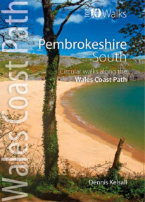 This lovely little book explores the ten best short circular walks along the southern part of the Pembrokeshire coast — itself part of the Wales Coast Path. The Pembrokeshire coast alters subtly from north to south. The southern rocks are far younger and the coast tends to be south-facing, too, creating a gentler hinterland. This influenced historical development and culture, for although the Norman advance extended throughout Pembrokeshire, settlement focused on the more fertile southern corner. It became known as ‘Little England’, with English rather than Welsh spoken, a tradition reflected in place names. Before reliable roads, trade and prosperity favoured the coast, and because the railways came late here, Pembrokeshire was largely ignored by the Industrial Revolution. Unspoiled and breathtakingly scenic, the coast is captivating every step of the way.
 -
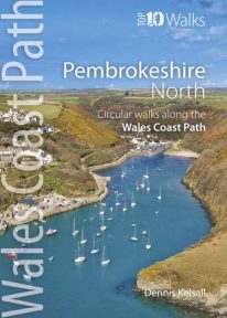 This photogenic book will take you on ten short circular walks along the northern part of the Pembrokeshire section of the Wales Coast Path. Pembrokeshire’s north coast has a rugged and remote quality, reflecting the wildness of the hills that rise behind. It was largely ignored during the Norman colonisation and even today beyond St Dogmael’s there are only a handful of coastal communities. Yet burial cairns, promontory forts and a pre-historic trackway across the Preseli Hills indicate widespread prehistoric settlement, and it was an important focus during the spread of Celtic Christianity. Fishing, farming and stock grazing were traditional ways of life, but the Industrial Revolution briefly opened coastal quarrying and the railway made Fishguard an important Irish port. Today, it is a relative backwater but the coast has an untamed beauty, its flowers, birds, seals and porpoises making it a truly special place.
 -
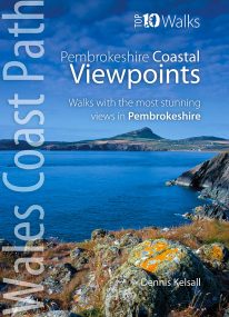 by Dennis Kelsall This attractive and good looking book will take you on ten short circular walks to some of the finest and most iconic views and viewpoints along the rugged Pembrokeshire coast, in West Wales. For some hillwalkers, the ‘view’ is only achieved on attaining the summit. But here, the endless convolutions of the coastline create an ever changing scene, both in front and behind; with every step shifting the perspective, bringing something different into sight. While the distant view can stretch for miles, inlets, coves and bays may remain hidden, only revealing themselves at the last moment. More immediately, the cliffs are broken by crevices, ledges, caves and natural arches, while just offshore are stacks and wave-washed shoals. Behind, the hinterland is a patchwork of hill, common and agriculture, while the vista out to the sea is endlessly changed by the weather, tide and hour. And, where accessible, the prospect from the beach is different again. Memorable walks to unmissable views.
 -
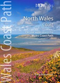 Product Description One of nine books in the new Top 10 Walks: Wales Coast Path series. This attractive and cleverly structured guidebook gives walkers the ten best walks on the southern part of the South Wales Coast section of the Wales Coast Path, in a popular pocketable format. With clear information, an overview and introduction for each walk, expertly written numbered directions, Ordnance Survey maps, superb, eye-grabbing panoramic photographs, and interpretation of points of interest along the way, these guides set a new standard in clarity, appeal and ease-of-use. Contents The Wales Coast Path: an introduction Top Ten Walks: Wales Coast Path: North Wales Coast: a photo mosaic
- Holywell & Basinwerk Abbey
- Talacre & Gronant dunes
- Prestatyn to Graig Fawr
- Rhyl to Rhuddlan Castle
- Little Orme
- Around the Great Orme
- Conwy Mountain
- Above Penmaenmawr
- Aber Falls
- Lafan Sands - low/high loop
-
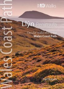 This handy little guide book gives you the ten very best short circular walks along the Llŷn peninsula section of the Wales Coast Path The Llŷn pushes 30 miles into the Irish Sea, tipped by the holy isle of Bardsey, or Ynys Enlli — ‘the island of 20,000 saints’. This remote and unspoilt landscape is characterised by traditional farms and compact villages, punctuated by volcanic hills. Its relative isolation has made it a haven for the Welsh language and culture. Sea cliffs, offshore rocks and intimate coves dominate the northern coast, while the gentler southern coast promises sandy beaches and holiday towns like Abersoch and Pwllheli. But for sheer beauty, tranquillity and wildlife, the Llŷn is hard to beat.
 -
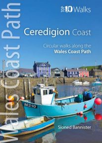 This handy pocket size book will take you on ten of the best short circular walks along the Ceredigion coast. Cardigan Bay embraces the dramatic sweep of the Welsh coastline, from Bardsey Island on the tip of the Llŷn in the north, to Strumble Head in Pembrokeshire in the south. It takes in parts of two National Parks: Snowdonia and Pembrokeshire, and three different counties: Gwynedd, Ceredigion and Pembrokeshire. The southern half of Cardigan Bay covers the rugged coastline between Aberystwyth and Cardigan. The dramatic cliffs and hidden coves are part of the Ceredigion Coast Path: a 60 mile trail that promises stunning views and some of the best opportunities for walkers to spot maritime wildlife in Wales.
 -
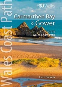 This handy, pocket size book will take you on the ten best short circular walks along the Carmarthen Bay and Gower stretch of the Wales Coast Path. Carmarthen Bay embraces an area of Welsh coast stretching from south Pembrokeshire to the Gower Peninsula. Long, sandy beaches and wide, silty estuaries dominate much of the bay, though there are also high cliffs and rocky coves in places. The Gower Peninsula, at the eastern end of the bay, is a small but priceless gem. Britain’s first official Area of Outstanding Natural Beauty (AONB), the peninsula contains an astonishing variety of landscapes: dunes, marshland, high cliffs, windswept downs, wooded valleys, picturesque villages and glorious sandy beaches — all linked by a superb footpath network.