-
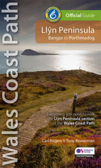 NEW - 4th edition updated and revised – 2023 This Official Guide to the Llŷn Peninsula section of the Wales Coast Path contains everything local and long-distance walkers need. The Llŷn offers some of the finest coastal walking in North Wales. Its distinctive landscape is characterised by traditional farms, compact villages and volcanic hills encircled by the ever-present sea. Along the way, you'll pass Iron Age hillforts, pilgrims' churches, medieval castles, a hidden valley, a pub on the beach, tiny coves, sandy bays and Bardsey island balanced at the tip of this ancient 'Land's End of Wales'. Keep an eye out, too, for seabirds, wild goats, choughs, seals, dolphins, wildflowers and butterflies. The Llŷn coast path really is a walkers' paradise.
 -
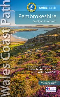 NEW, updated and revised edition - 2021 One of seven Official Guides to the Wales Coast Path The 186 mile/300km long Pembrokeshire section of the Wales Coast Path runs through some of Wales’ most varied and dramatic coastal scenery — high, rugged cliffs and long sandy bays, Pembroke Castle, St David’s cathedral and St Govan’s remote cliff-wrapped chapel, with several large offshore islands. Pembrokeshire is also Britain’s only coastal National Park. This Official Guide splits the route into 14 convenient day sections, each of about 10-17 miles / 16-27 kilometres. It contains everything local and long-distance walkers need to enjoy the path.
 -
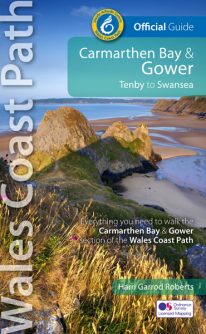 NEW, updated and revised edition - 2021 One of seven Official Guides to the Wales Coast Path The Carmarthen Bay and Gower section of the Wales Coast Path runs for 120 miles/193 kilometres between Amroth, on the eastern edge of the Pembrokeshire Coast National Park, to Swansea, on the landward side of the Gower Peninsula. This Official Guide splits the route into 12 convenient day sections, each of about 10-17 miles / 16-27 kilometres. It contains everything local and long-distance walkers need to enjoy the path and includes: An overview of Carmarthen Bay and Gower with dedicated history and wildlife sections Twelve day-walk sections with detailed route descriptions and full, enhanced Ordnance Survey mapping Distance charts, section overviews, background information and interpretation of places of interest Stunning professional photographs throughout Information on accommodation, public transport, local information, weather, and tidal links.
 -
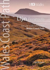 This handy little guide book gives you the ten very best short circular walks along the Llŷn peninsula section of the Wales Coast Path The Llŷn pushes 30 miles into the Irish Sea, tipped by the holy isle of Bardsey, or Ynys Enlli — ‘the island of 20,000 saints’. This remote and unspoilt landscape is characterised by traditional farms and compact villages, punctuated by volcanic hills. Its relative isolation has made it a haven for the Welsh language and culture. Sea cliffs, offshore rocks and intimate coves dominate the northern coast, while the gentler southern coast promises sandy beaches and holiday towns like Abersoch and Pwllheli. But for sheer beauty, tranquillity and wildlife, the Llŷn is hard to beat.
 -
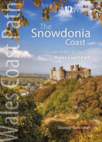 This lovely little book contains the ten best short circular walks along the north part of the Cardigan Bay section of the Wales Coast Path Cardigan Bay embraces the dramatic sweep of the Welsh coastline, from Bardsey island on the tip of Lleyn, in the north, to Strumble Head in Pembrokeshire, in the south. It takes in parts of two National Parks: Snowdonia and Pembrokeshire, and three different counties, Gwynedd, Ceredigion and Pembrokeshire. The striking northern section between Porthmadog and Borth is as varied as it is beautiful. Characterised by vast beaches and rugged cliffs, the coast offers superb walking with ever-changing views and a wealth of wildlife.
 -
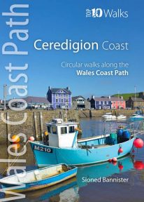 This handy pocket size book will take you on ten of the best short circular walks along the Ceredigion coast. Cardigan Bay embraces the dramatic sweep of the Welsh coastline, from Bardsey Island on the tip of the Llŷn in the north, to Strumble Head in Pembrokeshire in the south. It takes in parts of two National Parks: Snowdonia and Pembrokeshire, and three different counties: Gwynedd, Ceredigion and Pembrokeshire. The southern half of Cardigan Bay covers the rugged coastline between Aberystwyth and Cardigan. The dramatic cliffs and hidden coves are part of the Ceredigion Coast Path: a 60 mile trail that promises stunning views and some of the best opportunities for walkers to spot maritime wildlife in Wales.
 -
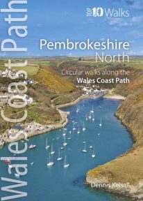 This photogenic book will take you on ten short circular walks along the northern part of the Pembrokeshire section of the Wales Coast Path. Pembrokeshire’s north coast has a rugged and remote quality, reflecting the wildness of the hills that rise behind. It was largely ignored during the Norman colonisation and even today beyond St Dogmael’s there are only a handful of coastal communities. Yet burial cairns, promontory forts and a pre-historic trackway across the Preseli Hills indicate widespread prehistoric settlement, and it was an important focus during the spread of Celtic Christianity. Fishing, farming and stock grazing were traditional ways of life, but the Industrial Revolution briefly opened coastal quarrying and the railway made Fishguard an important Irish port. Today, it is a relative backwater but the coast has an untamed beauty, its flowers, birds, seals and porpoises making it a truly special place.
 -
Coming Soon
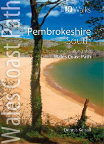 This lovely little book explores the ten best short circular walks along the southern part of the Pembrokeshire coast — itself part of the Wales Coast Path. The Pembrokeshire coast alters subtly from north to south. The southern rocks are far younger and the coast tends to be south-facing, too, creating a gentler hinterland. This influenced historical development and culture, for although the Norman advance extended throughout Pembrokeshire, settlement focused on the more fertile southern corner. It became known as ‘Little England’, with English rather than Welsh spoken, a tradition reflected in place names. Before reliable roads, trade and prosperity favoured the coast, and because the railways came late here, Pembrokeshire was largely ignored by the Industrial Revolution. Unspoiled and breathtakingly scenic, the coast is captivating every step of the way.
 -
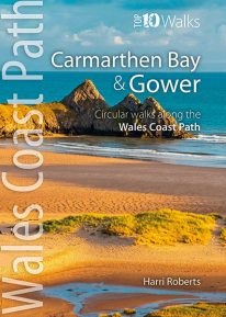 This handy, pocket size book will take you on the ten best short circular walks along the Carmarthen Bay and Gower stretch of the Wales Coast Path. Carmarthen Bay embraces an area of Welsh coast stretching from south Pembrokeshire to the Gower Peninsula. Long, sandy beaches and wide, silty estuaries dominate much of the bay, though there are also high cliffs and rocky coves in places. The Gower Peninsula, at the eastern end of the bay, is a small but priceless gem. Britain’s first official Area of Outstanding Natural Beauty (AONB), the peninsula contains an astonishing variety of landscapes: dunes, marshland, high cliffs, windswept downs, wooded valleys, picturesque villages and glorious sandy beaches — all linked by a superb footpath network.
 -
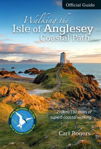 The Official Guide to the Isle of Anglesey/Ynys Mon Coastal Path New Edition - rewalked and wholly updated 2018 The route is described in a clockwise direction, starting and finishing at Holyhead. The 130 mile/210km long Isle of Anglesey Coastal Path passes through some of the grandest coastal scenery in Wales — wide sandy bays and estuaries, intimate coves, dramatic cliffs and rocky islets, sand dunes and forests—much of it designated ‘An Area of Outstanding Natural Beauty (AONB). This Official Guide has been designed to provide all the information needed to plan and walk the coastal path and includes:
- Information on accommodation, public transport, seasonal closures and tidal restrictions
- Twelve day-walk chapter sections with detailed route descriptions and full Ordnance Survey mapping
- Fascinating notes on points of interest
-
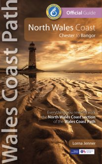 New Edition - rewalked and updated 2022 One of seven Official Guides to the Wales Coast Path The 80 mile/125km long North Wales Coast section of the Wales Coast Path between Chester and Bangor runs alongside the broad Dee Estuary and traditional seaside towns past Conwy Castle, the Great Orme, Penmaenmawr and Conwy Mountain to the university town of Bangor on the Menai Strait. This Official Guide splits the route into 8 convenient day sections, each of about 9-12 miles / 14-20 kilometres. It contains everything local and long-distance walkers need to enjoy the path.
 -
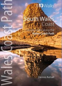 Product Description One of nine books in the new Top 10 Walks: Wales Coast Path series. The past two centuries have wrought more change on South Wales than any other section of the country’s coast. Until the end of the 18th century, Swansea, Barry and even Cardiff were just small ports, though their ships traded far and wide. The industry of iron and coal changed things forever but most of the coast and its immediate hinterland were left unspoiled and elsewhere, nature has reclaimed some of what was taken. The coast is one of extreme contrasts, ranging from great dune systems through sheer cliffs to miles of coastal saltmarsh. Nowhere is far from a delightful stretch overlooking the sea, with fine views, nature and heritage all around.