-
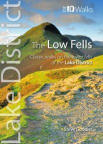 This superb pocket size book will take you on ten short circular walks to the ten best-known low fells in the Lake District The fells get their name from the Old Norse word, fjalls, which originally meant areas of rough upland grazing. Today, the Lakeland fells promise some of the best high level walking in England, and a real sense of freedom. But though the high fells often feature rocky summits, narrow edges and sheer cliffs, the lower fells, below the 2,000 foot contour, are greener, rounder and kinder. Walking on them can still be steep and strenuous, of course, but the routes are more suitable for the general walker. And the views are just as incredible.
 -
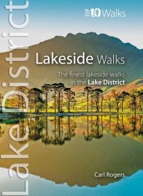 This popular pocket size book will take you on ten short circular walks to the finest lakeside paths in the Lake District. Lakeland’s characteristic lakes and meres are a legacy of the last Ice Age when vast ice sheets scoured out deep U-shaped valleys and upland combes. Today, sixteen main lakes and scores of smaller tarns punctuate the National Park. They include England’s longest lake (Windermere: 10½ miles long), and its deepest lake (Wast Water: 243 feet deep). Only Windermere, Derwent Water, Coniston Water and Ullswater have regular steamer and ferry services, yet every lake features dramatic waterside walks that will stay in your memory forever.
 -
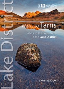 This smashing little book features ten short circular walks to the loveliest tarns in the Lake District. Norsemen, who dominated Lakeland 1,000 years ago, called the small bodies of water they found in the mountains tjorns—‘little lakes’ or , literally, ‘teardrops’. Now known as tarns, they are remnants of the last Ice Age when huge ice sheets scoured out hollows in the mountains that then filled with water. There are hundreds of tarns in the Lake District National Park: from tiny pools sparkling like blue jewels on high, lonely ridge tops, to small lakes sitting cold and moody at the base of sombre cliffs.
 -
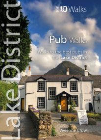 Here in one pocket size book are ten, easy, short circular walks to the finest Lake District pubs. The words ‘Lakeland’ and ‘pub’ go together like ‘bread’ and ‘butter’ or ‘Romeo’ and ‘Juliet’. The Lake District is a region that’s famed for its traditional inns and cosy, friendly village pubs almost as much as it’s famed for its magnificent walking country. So, what could be better than combining the two—enjoying a pint of local ale half-way through a gorgeous Sunday stroll, or a hearty meal at the end of a day’s hiking?
 -
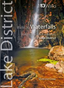 WINNER OF THE OUTDOOR WRITERS AND PHOTOGRAPHERS’ GUILD’S ‘BEST GUIDEBOOK’ AWARD 2013 This attractive pocket size book features ten easy, short circular walks to the most amazing Lake District waterfalls. The dramatic waterfalls of the Lake District are mostly a by-product of the last Ice Age — the awesome result of the ancient interplay of ice and rock. Given perpetual life by the region’s high rainfall, they come thundering down from the fells in a variety of forms. No two are the same. Many carry the name ‘force’—from the old Norse foss simply meaning ‘waterfall’—a remnant of the times when Norsemen dominated these uplands. Unmissable!
 -
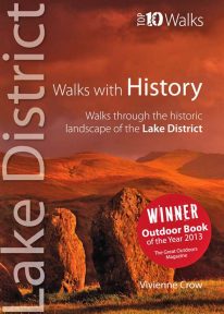 WINNER OF TGO’s ‘BEST GUIDEBOOK’ AWARD 2013 This award-winning book of short circular walks explores the ten most amazing historic sites in the Lake District. It may not seem obvious at first, but the rich human heritage of the area we now call the Lake District is evident all around us as we walk the fells and dales. From the enigmatic monuments built by prehistoric peoples to the industrial scars left in more modern times, centuries of human habitation have left their mark on this landscape. Keep your eyes and your imagination open, and you will come to realise that every step you take is a step through time. A worthy winner.
 -
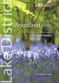 This lovely little book will take you on ten short circular walks through the finest woods and forests in the Lake District People seem to be drawn to trees, be they part of a landscape that has existed for centuries or planted in more modern times. There is something special about being in among their sturdy trunks, surrounded by a rich understorey with the sunlight piercing the canopy high above. In the Lake District, there is a huge variety of woodland — and no matter what their origins, what tree types grow there or how they have been managed, that extraordinary atmosphere never fails to nourish the soul.
 -
 This lovely little book contains the ten best short circular walks along the north part of the Cardigan Bay section of the Wales Coast Path Cardigan Bay embraces the dramatic sweep of the Welsh coastline, from Bardsey island on the tip of Lleyn, in the north, to Strumble Head in Pembrokeshire, in the south. It takes in parts of two National Parks: Snowdonia and Pembrokeshire, and three different counties, Gwynedd, Ceredigion and Pembrokeshire. The striking northern section between Porthmadog and Borth is as varied as it is beautiful. Characterised by vast beaches and rugged cliffs, the coast offers superb walking with ever-changing views and a wealth of wildlife.
 -
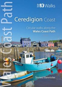 This handy pocket size book will take you on ten of the best short circular walks along the Ceredigion coast. Cardigan Bay embraces the dramatic sweep of the Welsh coastline, from Bardsey Island on the tip of the Llŷn in the north, to Strumble Head in Pembrokeshire in the south. It takes in parts of two National Parks: Snowdonia and Pembrokeshire, and three different counties: Gwynedd, Ceredigion and Pembrokeshire. The southern half of Cardigan Bay covers the rugged coastline between Aberystwyth and Cardigan. The dramatic cliffs and hidden coves are part of the Ceredigion Coast Path: a 60 mile trail that promises stunning views and some of the best opportunities for walkers to spot maritime wildlife in Wales.
 -
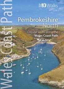 This photogenic book will take you on ten short circular walks along the northern part of the Pembrokeshire section of the Wales Coast Path. Pembrokeshire’s north coast has a rugged and remote quality, reflecting the wildness of the hills that rise behind. It was largely ignored during the Norman colonisation and even today beyond St Dogmael’s there are only a handful of coastal communities. Yet burial cairns, promontory forts and a pre-historic trackway across the Preseli Hills indicate widespread prehistoric settlement, and it was an important focus during the spread of Celtic Christianity. Fishing, farming and stock grazing were traditional ways of life, but the Industrial Revolution briefly opened coastal quarrying and the railway made Fishguard an important Irish port. Today, it is a relative backwater but the coast has an untamed beauty, its flowers, birds, seals and porpoises making it a truly special place.
 -
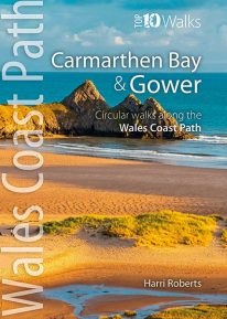 This handy, pocket size book will take you on the ten best short circular walks along the Carmarthen Bay and Gower stretch of the Wales Coast Path. Carmarthen Bay embraces an area of Welsh coast stretching from south Pembrokeshire to the Gower Peninsula. Long, sandy beaches and wide, silty estuaries dominate much of the bay, though there are also high cliffs and rocky coves in places. The Gower Peninsula, at the eastern end of the bay, is a small but priceless gem. Britain’s first official Area of Outstanding Natural Beauty (AONB), the peninsula contains an astonishing variety of landscapes: dunes, marshland, high cliffs, windswept downs, wooded valleys, picturesque villages and glorious sandy beaches — all linked by a superb footpath network.
 -
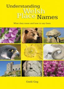 Puzzled by Welsh place names but want to know what they mean and how to say them? This fascinating, easy-to-use guide means non-Welsh speakers can now easily translate and understand place names all over Wales — on the map, on road signs, and out in the countryside. Armed with this insider knowledge, you’ll discover there’s a whole exciting new dimension to the Welsh landscape. In fact, Wales will never be quite the same again ….