-
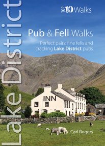 If you like walking up Lakeland's most iconic fells followed by a visit to an excellent and nearby pub or inn, then this is the book for you. Well-known outdoor author Carl Rogers cleverly combines some of Cumbria's finest fell walks with its best-loved pubs. They're a marriage made in heaven — with some super natural pairs such as the Kirkstile Inn at Loweswater with Melbreak literally just behind the pub. Up a fell and down a pint - what could be better?
 -
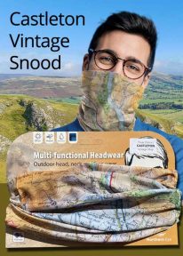
Peak District: Castleton (Vintage) - Neck Gaiter/Scarf/Snood
Wearable large-scale historic map artwork: Castleton in the Peak District
CASTLETON AND THE GREAT RIDGE LIE AT THE HEART OF THE PEAK DISTRICT NATIONAL PARK. The ever-popular town lies between the gentle limestone 'White Peak' to the south, and the starker gritstone 'Dark Peak' to the north. This attractive, silky smooth snood features historic coloured map artwork showing the area in detail. Note: The historic mapping used on this snood is not recommended for navigation. Walkers should carry the correct modern OS online or sheet map and compass. -
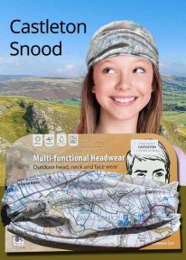
Peak District: Castleton - Neck Gaiter/Scarf/Snood
Wearable large-scale 1:25,000 Ordnance Survey map artwork: Castleton in the Peak District
CASTLETON AND THE GREAT RIDGE LIE AT THE HEART OF THE PEAK DISTRICT. This attractive, silky smooth snood features historic coloured map artwork showing the area in detail. The perfect souvenir or gift. Note: While the Ordnance Survey mapping used on the snood is up-to-date at the time of production, it is not recommended for navigation. Walkers should carry the correct OS online or sheet map and compass.Ordnance Survey Licence No.: 0100047867
-

Wales: Cadair Idris - Neck Gaiter/Scarf/Snood
Wearable large-scale 1:25,000 Ordnance Survey map artwork: Cadair Idris in Snowdonia
CADAIR IDRIS IS THE SECOND-HIGHEST MOUNTAIN IN THE SNOWDONIA NATIONAL PARK. Rightly popular with walkers, it stands at the southern end of the National Park near Dolgellau. This detailed Ordnance Survey mapping snood shows the shapely mountain and its three main routes of ascent, making it the ideal present or souvenir for everyone who has climbed, or dreams of climbing, this wonderful summit. Note: While the Ordnance Survey mapping used on the snood is up-to-date at the time of production, it is not recommended for navigation. Walkers should carry the correct OS online or sheet map and compass.Ordnance Survey Licence No.: 0100047867
-
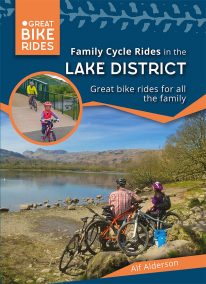 by Alf Alderson As one of the UK’s most beautiful regions it’s no surprise that the Lake Districtis so popular amongst cyclists. It also has a fearsome reputation — climbs such as Honister Pass and Whinlatter Pass are challenging enough to have featured in the Tour of Britain, whilst the grueling combination of Hardknott and Wrynose Passes between Little Langdale and Eskdale offers some of the toughest cycling in the country, with 33 per cent gradients in some places. But the Lake District is not all super-steep hills, fortunately! There are plenty of easy lakeside cycle paths and quiet country lanes, along with the mountain bike centres at Whinlatter and Grizedale, where even the youngest cycling enthusiast can get to know this beautiful landscape. So with a little effort, anyone can access some truly magnificent Cumbrian scenery on their bike
 -
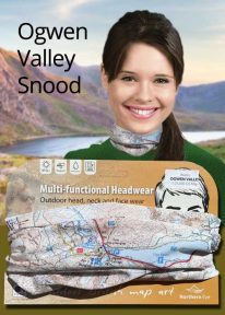
Wales: Tryfan & the Glyders - Neck Gaiter/Scarf/Snood
Wearable large-scale 1:25,000 Ordnance Survey map artwork: Tryfan & the Glyders in Snowdonia
WALES' FAMOUS OGWEN VALLEY is home to the shallow, ribbon lake of Llyn Ogwen (alongside the main A5) , which divides the two main mountain rages of the Snowdonia National Park — the Carneddau and the Glyderau. Key mountains here include mighty Tryfan and the Glyders. This detailed Ordnance Survey mapping snood shows the lake and its dramatic surroundings, making it the ideal present or souvenir for everyone who loves this iconic valley and its surrounding peaks. Note: While the Ordnance Survey mapping used on the snood is up-to-date at the time of production, it is not recommended for navigation. Walkers should carry the correct OS online or sheet map and compass.Ordnance Survey Licence No.: 0100047867
-
Coming Soon
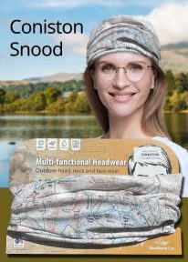
Lake District: Coniston - Neck Gaiter/Scarf/Snood
Wearable large-scale 1:25,000 Ordnance Survey map artwork: Coniston in the Lake District
CONISTON IS ONE OF THE LAKE DISTRICT'S LOVELIEST LAKES. Over five miles long and surrounded by the Cumbrian fells, Coniston is a justified favourite with visitors. The luxurious, silky neck tube features wearable large-scale 1:25,000 Ordnance Survey map artwork. Now you or a friend can own this stylish and permanent souvenir of an iconic part of the English Lake District. Note: While the Ordnance Survey mapping used on the snood is up-to-date at the time of production, it is not recommended for navigation. Walkers should carry the correct OS online or sheet map and compass.Ordnance Survey Licence No.: 0100047867
-
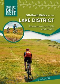 by Jon Sparks The second in a series of themed cycle guides to the Lake District, Off-Road Rides outlines a series of cycle rides filling the often-overlooked gap between easy forest roads and hardcore mountain biking. The routes seek out enjoyable tracks and trails, linked by quiet lanes. They include café and picnic stops, plus points of interest along the way.
 -
 by Vivienne Crow This exciting, new and interactive guide brings families with children ten of the very best family adventures in the Lake District National Park. With expertly-chosen adventures, superb photographs, clear information, an overview and introduction for each walk, expertly written numbered directions, large scale maps, and four themed interactive challenges for every adventure, these guides set a new standard in design, concept, clarity and ease-of-use.
 -
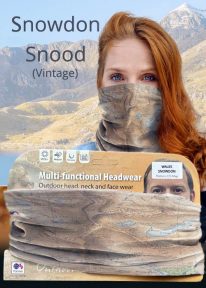
Snowdon - Neck Gaiter/Scarf/Snood
Wearable large-scale historic (1912) map artwork: Snowdon in Snowdonia
SOMETIMES CALLED 'THE TOP OF WALES', Snowdon is the highest and best-known peak in the country, reaching 1,085 metres (3,560 ft) above sea level. This historic, 1912 Ordnance Survey map snood shows the summit and all six main paths up, making it the ideal gift or souvenir for mountain fans everywhere. Note: The historic mapping used on this snood is not recommended for navigation. Walkers should carry the correct modern OS online or sheet map and a compass. -
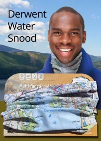
Lake District: Derwentwater - Neck Gaiter/Scarf/Snood
Wearable large-scale 1:25,000 Ordnance Survey map artwork: Derwentwater in the Lake District
DERWENT WATER IS ONE OF THE LAKE DISTRICT'S MOST POPULAR LAKES. Surrounded by fells, the island-dotted lake is three miles long and lies just to the south of Keswick. This luxurious, silky neck tube features wearable large-scale 1:25,000 Ordnance Survey map artwork of the lake and its beautiful shore. Now you or a friend can own this stylish and permanent souvenir of an iconic part of the English Lakes. Note: While the Ordnance Survey mapping used on the snood is up-to-date at the time of production, it is not recommended for navigation. Walkers should carry the correct OS online or sheet map and compass.Ordnance Survey Licence No.: 0100047867
-
 The ten walks featured here highlight the very best Welsh lighthouses and huge variety of the coastline of Wales. From vast expanses of sand, sea and sky, such as at Whiteford Point and Llanddwyn Island, to rugged coastline where seabirds wheel and skrike and porpoise and seals slide through the waves, like Strumble Head and South Stack, these walks to lighthouses guarantee a fine day out. All are circular, and vary from short and easy, like the to Talacre lighthouse, to longer and more demanding, such as that to St. Ann’s Head lighthouse — but none are beyond any reasonably fit and enthusiastic walker.