• Coming Soon

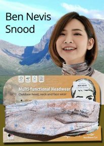
    Scotland: Ben Nevis - Neck Gaiter/Scarf/Snood

    Wearable large-scale 1:50,000 Ordnance Survey map artwork: Ben Nevis in Scotland

    BEN NEVIS IS THE HIGHEST MOUNTAIN IN SCOTLAND AND THE BRITISH ISLES. Rising to 1,345 metres (4,413 ft) above sea level, the summit is reached by around 100,000 visitors a year. This detailed Ordnance Survey mapping snood shows the mountain and its awe-inspiring surroundings, making it the ideal present or souvenir for everyone who loves this most famous of Scotland's mountains. Note: While the Ordnance Survey mapping used on the snood is up-to-date at the time of production, it is not recommended for navigation. Walkers should carry the correct OS online or sheet map and compass.
    Ordnance Survey Licence No.: 0100047867
  • Peak District: Castleton - Neck Gaiter/Scarf/Snood

    Wearable large-scale 1:25,000 Ordnance Survey map artwork: Castleton in the Peak District

    CASTLETON AND THE GREAT RIDGE LIE AT THE HEART OF THE PEAK DISTRICT. This attractive, silky smooth snood features historic coloured map artwork showing the area in detail. The perfect souvenir or gift. Note: While the Ordnance Survey mapping used on the snood is up-to-date at the time of production, it is not recommended for navigation. Walkers should carry the correct OS online or sheet map and compass.
    Ordnance Survey Licence No.: 0100047867
     
  • Peak District: Castleton (Vintage) - Neck Gaiter/Scarf/Snood

    Wearable large-scale historic map artwork: Castleton in the Peak District

    CASTLETON AND THE GREAT RIDGE LIE AT THE HEART OF THE PEAK DISTRICT NATIONAL PARK. The ever-popular town lies between the gentle limestone 'White Peak' to the south, and the starker gritstone 'Dark Peak' to the north. This attractive, silky smooth snood features historic coloured map artwork showing the area in detail. Note: The historic mapping used on this snood is not recommended for navigation. Walkers should carry the correct modern OS online or sheet map and compass.  

Title

Go to Top