Walking, hiking, cycling, scrambling and climbing books, guides and maps for North Wales and the Snowdonia National Park.
The popular, pocket-size Top 10 Walks series contain the very best classic short themed walks in North Wales and Snowdonia National Park.
Key North Wales and Snowdonia National Park themes include: Pub Walks, Tea Shop Walks, Coastal Walks, Hill walks and Easy Summits, and Mountain Walks.
-
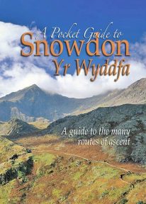 This book is a new and wholly updated edition of the popular, full-colour, handy sized guide to all of Snowdon’s recognised routes of ascent – from the six ‘Classic Paths’ to the many lesser known and less frequented routes.
 -
Coming Soon
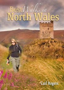 This authoritative walking guide will take you to some of the very best, tried-and-tested circular walking routes across NorthWales. The book covers walks in Anglesey, the Lleyn Peninsula, Snowdonia, the Conwy Valley, the Clwydian Range, and the Vale of Llangollen.
 -
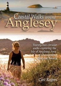 Coastal Walks around Anglesey contains 22 easy, circular walks that sample just about everything the island’s coastline has to offer. The routes have been chosen with all walkers in mind – from those looking for a casual half-day walk to add variety to a holiday, to the more ambitious who may complete two or more routes, perhaps as a less strenuous alternative to Snowdonia.
 -
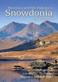 Mountain and Hill Walking in Snowdonia is a two volume in-depth guide to every summit of note in the Snowdonia National Park. Each recommended route is described in detail and accompanied by a full colour relief map. All the routes are circular and include information on parking, distance and height gained. Volume 1 covers the northern half of the National Park.
 -
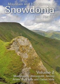 Mountain and Hill Walking in Snowdonia is a two volume in-depth guide to every summit of note in the Snowdonia National Park. Each recommended route is described in detail and accompanied by a full colour relief map. All the routes are circular and include information on parking, distance and height gained. Volume 2 covers the southern half of the National Park.
 -
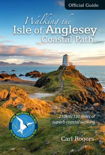 The Official Guide to the Isle of Anglesey/Ynys Mon Coastal Path New Edition - rewalked and wholly updated 2018 The route is described in a clockwise direction, starting and finishing at Holyhead. The 130 mile/210km long Isle of Anglesey Coastal Path passes through some of the grandest coastal scenery in Wales — wide sandy bays and estuaries, intimate coves, dramatic cliffs and rocky islets, sand dunes and forests—much of it designated ‘An Area of Outstanding Natural Beauty (AONB). This Official Guide has been designed to provide all the information needed to plan and walk the coastal path and includes:
- Information on accommodation, public transport, seasonal closures and tidal restrictions
- Twelve day-walk chapter sections with detailed route descriptions and full Ordnance Survey mapping
- Fascinating notes on points of interest
-
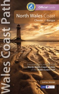 New Edition - rewalked and updated 2022 One of seven Official Guides to the Wales Coast Path The 80 mile/125km long North Wales Coast section of the Wales Coast Path between Chester and Bangor runs alongside the broad Dee Estuary and traditional seaside towns past Conwy Castle, the Great Orme, Penmaenmawr and Conwy Mountain to the university town of Bangor on the Menai Strait. This Official Guide splits the route into 8 convenient day sections, each of about 9-12 miles / 14-20 kilometres. It contains everything local and long-distance walkers need to enjoy the path.
 -
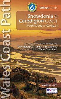 NEW, updated and revised edition – 2022 One of seven Official Guides to the Wales Coast Path The Snowdonia & Ceredigion coast offers a tremendous variety of landscape to those who walk its entire 132 miles/213 kilometres: from high, airy cliff-tops to secluded coves; from estuarine salt marshes to beaches backed by tremendous dune systems that stretch on for miles. And with that diversity comes a huge range of wildlife, including seabirds, choughs, dolphins and rare wildflowers. The history too changes with every twist and turn of this fascinating route: visitors should always be prepared for the unexpected in a region that contains the ruins of once mighty castles and has links with characters as disparate as King Arthur and members of the rock band Led Zeppelin.
 -
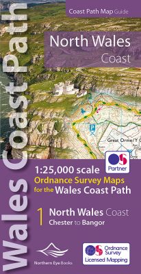 Enhanced, large scale (1: 25,000) Ordnance Survey mapping in a handy atlas format with all the mapping you need to walk a complete North Wales Coast section of the Wales Coast Path. Continuous OS mapping covering the complete route from Chester to Bangor, on the Menai Strait. Contains generous coastal extracts from large-scale OS Explorer maps 266, 265, 264 and OL17. The North Wales Coast Ordnance Survey mapping book is part of a series of map atlases covering the whole of the 870-mile long Wales Coast Path. The enhanced OS 1:25,000 maps are accurate, up-to-date and reliable. Additional map symbols show tea shops, cafes, extra parking, and public toilets. A brief introduction to the North Wales Coast includes a fascinating photo mosaic highlighting notable views, places of interest and wildlife you'll meet along the way. There is also a section of detailed Useful Information at the back of the atlas. Laminated flapped covers showing Wales Coast Path signs and waymarkers, route details and map symbols make these atlases simple and easy to use. The map books’ dimensions are 215mm x 107mm and they fit easily into a standard map pocket.
- Large scale Ordnance Survey Explorer mapping for the complete North Wales Coast in a handy atlas format.
- Highlighted official route of the Wales Coast Path.
- On-map symbols showing amenities at main towns and villages.
- Introduction with attractive photo mosaic.
- Additional useful information
-
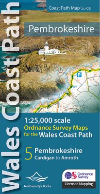 Enhanced, large scale (1: 25,000) Ordnance Survey mapping in a handy atlas format with all the mapping you need to walk a complete Pembrokeshire coast section of the Wales Coast Path. Continuous OS mapping covering the complete route from St Dogmael's near Cardigan to Amroth, on the Carmarthenshire border. Contains generous coastal extracts from large-scale OS Explorer maps OL 35 and OL36. The Pembrokeshire Coast Ordnance Survey mapping book is part of a series of map atlases covering the whole of the 870-mile long Wales Coast Path. The enhanced OS 1:25,000 maps are accurate, up-to-date and reliable. Additional map symbols show tea shops, cafes, extra parking, and public toilets. A brief introduction to the Pembrokeshire Coast includes a fascinating photo mosaic highlighting notable views, places of interest and wildlife you'll meet along the way. There is also a section of detailed Useful Information at the back of the atlas. Laminated flapped covers showing Wales Coast Path signs and waymarkers, route details and map symbols make these atlases simple and easy to use. The map books’ dimensions are 215mm x 107mm and they fit easily into a standard map pocket.
- Large scale Ordnance Survey Explorer mapping for the complete North Wales Coast in a handy atlas format.
- Highlighted official route of the Wales Coast Path.
- On-map symbols showing amenities at main towns and villages.
- Introduction with attractive photo mosaic.
- Additional useful information
-
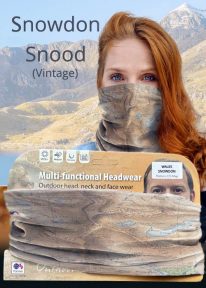
Snowdon - Neck Gaiter/Scarf/Snood
Wearable large-scale historic (1912) map artwork: Snowdon in Snowdonia
SOMETIMES CALLED 'THE TOP OF WALES', Snowdon is the highest and best-known peak in the country, reaching 1,085 metres (3,560 ft) above sea level. This historic, 1912 Ordnance Survey map snood shows the summit and all six main paths up, making it the ideal gift or souvenir for mountain fans everywhere. Note: The historic mapping used on this snood is not recommended for navigation. Walkers should carry the correct modern OS online or sheet map and a compass. -

Wales: Cadair Idris - Neck Gaiter/Scarf/Snood
Wearable large-scale 1:25,000 Ordnance Survey map artwork: Cadair Idris in Snowdonia
CADAIR IDRIS IS THE SECOND-HIGHEST MOUNTAIN IN THE SNOWDONIA NATIONAL PARK. Rightly popular with walkers, it stands at the southern end of the National Park near Dolgellau. This detailed Ordnance Survey mapping snood shows the shapely mountain and its three main routes of ascent, making it the ideal present or souvenir for everyone who has climbed, or dreams of climbing, this wonderful summit. Note: While the Ordnance Survey mapping used on the snood is up-to-date at the time of production, it is not recommended for navigation. Walkers should carry the correct OS online or sheet map and compass.Ordnance Survey Licence No.: 0100047867