Walking, hiking, cycling, scrambling and climbing books, guides and maps for North Wales and the Snowdonia National Park.
The popular, pocket-size Top 10 Walks series contain the very best classic short themed walks in North Wales and Snowdonia National Park.
Key North Wales and Snowdonia National Park themes include: Pub Walks, Tea Shop Walks, Coastal Walks, Hill walks and Easy Summits, and Mountain Walks.
-
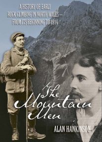 The fascinating inside story of pioneer rock climbers in Snowdonia, from the closing decades of the nineteenth century until the outbreak of the First World War.
 -
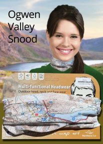
Wales: Tryfan & the Glyders - Neck Gaiter/Scarf/Snood
Wearable large-scale 1:25,000 Ordnance Survey map artwork: Tryfan & the Glyders in Snowdonia
WALES' FAMOUS OGWEN VALLEY is home to the shallow, ribbon lake of Llyn Ogwen (alongside the main A5) , which divides the two main mountain rages of the Snowdonia National Park — the Carneddau and the Glyderau. Key mountains here include mighty Tryfan and the Glyders. This detailed Ordnance Survey mapping snood shows the lake and its dramatic surroundings, making it the ideal present or souvenir for everyone who loves this iconic valley and its surrounding peaks. Note: While the Ordnance Survey mapping used on the snood is up-to-date at the time of production, it is not recommended for navigation. Walkers should carry the correct OS online or sheet map and compass.Ordnance Survey Licence No.: 0100047867
-
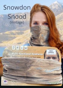
Snowdon - Neck Gaiter/Scarf/Snood
Wearable large-scale historic (1912) map artwork: Snowdon in Snowdonia
SOMETIMES CALLED 'THE TOP OF WALES', Snowdon is the highest and best-known peak in the country, reaching 1,085 metres (3,560 ft) above sea level. This historic, 1912 Ordnance Survey map snood shows the summit and all six main paths up, making it the ideal gift or souvenir for mountain fans everywhere. Note: The historic mapping used on this snood is not recommended for navigation. Walkers should carry the correct modern OS online or sheet map and a compass. -
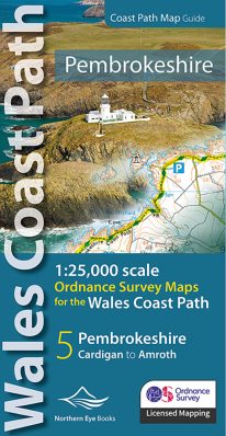 Enhanced, large scale (1: 25,000) Ordnance Survey mapping in a handy atlas format with all the mapping you need to walk a complete Pembrokeshire coast section of the Wales Coast Path. Continuous OS mapping covering the complete route from St Dogmael's near Cardigan to Amroth, on the Carmarthenshire border. Contains generous coastal extracts from large-scale OS Explorer maps OL 35 and OL36. The Pembrokeshire Coast Ordnance Survey mapping book is part of a series of map atlases covering the whole of the 870-mile long Wales Coast Path. The enhanced OS 1:25,000 maps are accurate, up-to-date and reliable. Additional map symbols show tea shops, cafes, extra parking, and public toilets. A brief introduction to the Pembrokeshire Coast includes a fascinating photo mosaic highlighting notable views, places of interest and wildlife you'll meet along the way. There is also a section of detailed Useful Information at the back of the atlas. Laminated flapped covers showing Wales Coast Path signs and waymarkers, route details and map symbols make these atlases simple and easy to use. The map books’ dimensions are 215mm x 107mm and they fit easily into a standard map pocket.
- Large scale Ordnance Survey Explorer mapping for the complete North Wales Coast in a handy atlas format.
- Highlighted official route of the Wales Coast Path.
- On-map symbols showing amenities at main towns and villages.
- Introduction with attractive photo mosaic.
- Additional useful information
-
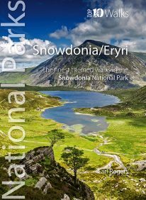 Discover the very best of the dramatic Snowdonia National Park, in North Wales. These ten themed walks will take you to the best and most iconic places across Snowdonia, from the mighty Aber Falls in the north, to Cadair Idris, in the south. Famous for its lofty mountains and open hills, Snowdonia is characterised, too, by dramatic upland lakes and tarns enfolded within glacial troughs and valleys, and short, steep rivers tumbling to the sea. Discover vast empty beaches, friendly pubs and stunning views, hidden lakes and awesome waterfalls, challenging hills and mighty mountains. Every one is a walk to enjoy and savour on the day, and to remember long afterwards.
 -
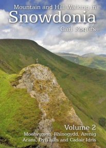 Mountain and Hill Walking in Snowdonia is a two volume in-depth guide to every summit of note in the Snowdonia National Park. Each recommended route is described in detail and accompanied by a full colour relief map. All the routes are circular and include information on parking, distance and height gained. Volume 2 covers the southern half of the National Park.
 -
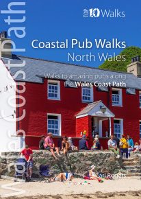
North Wales' best coastal pub walks
The comfortable, friendly and often upmarket pubs along the North Wales coast complement the walking on this superb stretch of the Wales Coast Path. Each walk incorporates a section of the Wales Coast Path, and starts and finishes close to a great, carefully selected pub. Combined, they cover the very best stretches of North Wales' coastline, one of striking contrasts and wonderful surprises. The easy, circular pub walks take in the North Wales Coast between Chester and Caernarfon, the Isle of Anglesey, and the remote Llyn peninsula. All the pubs are situated either right on the coast or a short hop inland — some in coves and harbours, some in the dunes or close to clifftops, others almost on the sand — and the majority are open all day. With the pubs often open all year and the walking good in all seasons, the North Wales Coast, Anglesey and the Llyn are quite rightly a year-round destination. -
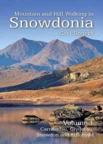 Mountain and Hill Walking in Snowdonia is a two volume in-depth guide to every summit of note in the Snowdonia National Park. Each recommended route is described in detail and accompanied by a full colour relief map. All the routes are circular and include information on parking, distance and height gained. Volume 1 covers the northern half of the National Park.
 -
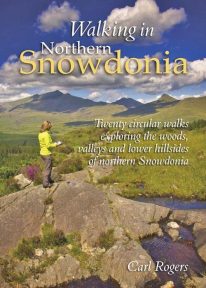 This attractive book explores twenty of the best low level circular walks in northern Snowdonia. Walking in Northern Snowdonia is dedicated to the northern half of the National Park, bounded by the Conwy Valley to the east, Glyn Lledr and the Vale of Ffestiniog to the south and Cwm Pennant to the west. Twenty circular walks are described, ranging in length from 4½ to 9 miles, which explore the woods, valleys and lower hillsides of this unique and beautiful area.
 -
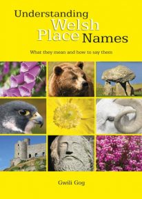 Puzzled by Welsh place names but want to know what they mean and how to say them? This fascinating, easy-to-use guide means non-Welsh speakers can now easily translate and understand place names all over Wales — on the map, on road signs, and out in the countryside. Armed with this insider knowledge, you’ll discover there’s a whole exciting new dimension to the Welsh landscape. In fact, Wales will never be quite the same again ….
 -
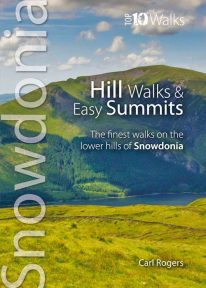 One of a series of four books for Snowdonia in the popular Top 10 Walks series. Handy, pocket-sized, full colour walking guides written by experts. The perfect impulse buy. Free display stands available. Other titles in the series include: Mountain Walks, Ridge Walks & Scrambles and Pub Walks. Uses Ordnance Survey mapping.
