-
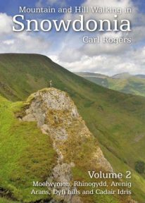 Mountain and Hill Walking in Snowdonia is a two volume in-depth guide to every summit of note in the Snowdonia National Park. Each recommended route is described in detail and accompanied by a full colour relief map. All the routes are circular and include information on parking, distance and height gained. Volume 2 covers the southern half of the National Park.
 -
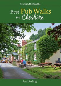 by Jen Darling CHESHIRE IS WELL KNOWN for both its beautiful countryside and its country pubs. This fully revised and updated, 3rd edition of a classic guide book combines the two with superb walks through varied countryside, each one visiting a walker-friendly pub that is well known for its food and drink. The 220-page book ideal for those with a connoisseur’s interest in Real Ale, and for walkers wanting a convenient starting point and route directions - plus some of the best pub lunches in Cheshire. There are 30 circular walks included, covering the entire county from west to east and north to south. Each walk is graded in terms of mileage and difficulty — so families with young children can choose the easy ones, and enthusiasts can find more challenging routes to work up a thirst!
 -
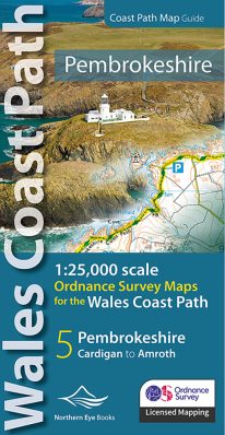 Enhanced, large scale (1: 25,000) Ordnance Survey mapping in a handy atlas format with all the mapping you need to walk a complete Pembrokeshire coast section of the Wales Coast Path. Continuous OS mapping covering the complete route from St Dogmael's near Cardigan to Amroth, on the Carmarthenshire border. Contains generous coastal extracts from large-scale OS Explorer maps OL 35 and OL36. The Pembrokeshire Coast Ordnance Survey mapping book is part of a series of map atlases covering the whole of the 870-mile long Wales Coast Path. The enhanced OS 1:25,000 maps are accurate, up-to-date and reliable. Additional map symbols show tea shops, cafes, extra parking, and public toilets. A brief introduction to the Pembrokeshire Coast includes a fascinating photo mosaic highlighting notable views, places of interest and wildlife you'll meet along the way. There is also a section of detailed Useful Information at the back of the atlas. Laminated flapped covers showing Wales Coast Path signs and waymarkers, route details and map symbols make these atlases simple and easy to use. The map books’ dimensions are 215mm x 107mm and they fit easily into a standard map pocket.
- Large scale Ordnance Survey Explorer mapping for the complete North Wales Coast in a handy atlas format.
- Highlighted official route of the Wales Coast Path.
- On-map symbols showing amenities at main towns and villages.
- Introduction with attractive photo mosaic.
- Additional useful information
-
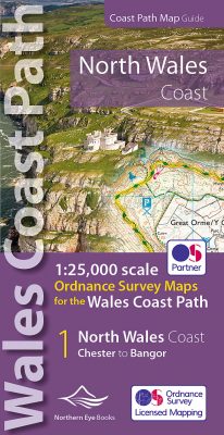 Enhanced, large scale (1: 25,000) Ordnance Survey mapping in a handy atlas format with all the mapping you need to walk a complete North Wales Coast section of the Wales Coast Path. Continuous OS mapping covering the complete route from Chester to Bangor, on the Menai Strait. Contains generous coastal extracts from large-scale OS Explorer maps 266, 265, 264 and OL17. The North Wales Coast Ordnance Survey mapping book is part of a series of map atlases covering the whole of the 870-mile long Wales Coast Path. The enhanced OS 1:25,000 maps are accurate, up-to-date and reliable. Additional map symbols show tea shops, cafes, extra parking, and public toilets. A brief introduction to the North Wales Coast includes a fascinating photo mosaic highlighting notable views, places of interest and wildlife you'll meet along the way. There is also a section of detailed Useful Information at the back of the atlas. Laminated flapped covers showing Wales Coast Path signs and waymarkers, route details and map symbols make these atlases simple and easy to use. The map books’ dimensions are 215mm x 107mm and they fit easily into a standard map pocket.
- Large scale Ordnance Survey Explorer mapping for the complete North Wales Coast in a handy atlas format.
- Highlighted official route of the Wales Coast Path.
- On-map symbols showing amenities at main towns and villages.
- Introduction with attractive photo mosaic.
- Additional useful information
-
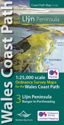 Enhanced, large scale (1: 25,000) Ordnance Survey mapping in a handy atlas format with all the mapping you need to walk a complete circuit of the Anglesey section of the Wales Coast Path. Continuous OS mapping covering the complete route from Bangor to Porthmadog. Contains coastal extracts from large scale Explorer maps 253 and 254. The Llyn Peninsula Ordnance Survey mapping book is part of a series of map atlases covering the whole of the 870-mile long Wales Coast Path. The enhanced OS 1:25,000 maps are accurate, up-to-date and reliable. Additional map symbols show tea shops, cafes, extra parking, and public toilets. A brief introduction to the Llyn Peninsula includes a fascinating photo mosaic highlighting notable views, places of interest and wildlife you'll meet along the way. There is also a section of detailed Useful Information at the back of the atlas. Laminated flapped covers showing Wales Coast Path signs and waymarkers, route details and map symbols make these atlases simple and easy to use. The map books’ dimensions are 215mm x 107mm and they fit easily into a standard map pocket.
- Large scale Ordnance Survey Explorer mapping for the complete coast of the Llyn Peninsula in a handy atlas format.
- Highlighted official route of the Wales Coast Path.
- On-map symbols showing amenities at main towns and villages.
- Introduction with attractive photo mosaic.
- Additional useful information
-
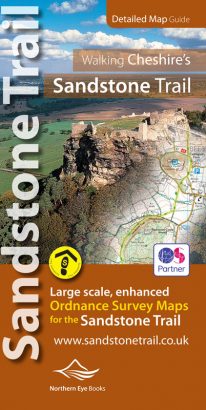
Large-scale Ordnance Survey maps for walking Cheshire's Sandstone Trail in a handy pocket size book.
Cheshire’s Sandstone Trail is probably the most popular middle-distance walk in Northwest England. Here, in handy, pocket size book format are all the maps you need to walk Cheshire's entire 55 kilometre/34 mile Trail.- Enlarged and enhanced, large scale 1:25,000 Ordnance Survey mapping for the whole Sandstone Trail
- Up-to-date route of Sandstone Trail clearly highlighted in yellow
- Extra map symbols for pubs, tea rooms, parking and more
- Trail introduction and photo mosaic
- Useful information section
- Ideal for walkers and all outdoor enthusiasts along Cheshire's sandstone ridge
- Contains relevant mapping from two OS maps for the price of one
-
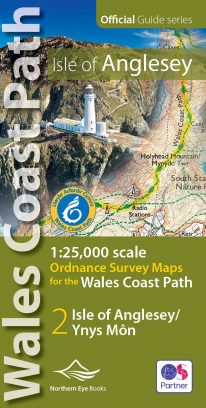 Enhanced, large scale (1: 25,000) Ordnance Survey mapping in a handy atlas format with all the mapping you need to walk a complete circuit of the Anglesey section of the Wales Coast Path. Continuous OS mapping covering the complete circuit from Menai Bridge. Contains coastal extracts from large scale Explorer maps 262 and 263. The Isle of Anglesey/Ynys Mon Ordnance Survey mapping book is part of a series of map atlases covering the whole of the 870-mile long Wales Coast Path. The enhanced OS 1:25,000 maps are accurate, up-to-date and reliable. Additional map symbols show tea shops, cafes, extra parking, and public toilets. A brief introduction to Anglesey includes a fascinating photo mosaic highlighting notable views, places of interest and wildlife you'll meet along the way. There is also a section of detailed Useful Information at the back of the atlas. Laminated flapped covers showing Wales Coast Path signs and waymarkers, route details and map symbols make these atlases simple and easy to use. The map books’ dimensions are 215mm x 107mm and they fit easily into a standard map pocket.
- Large scale Ordnance Survey Explorer mapping for the complete coast of the Isle of Anglesey/Ynys Mon in a handy atlas format.
- Highlighted official route of the Wales Coast Path.
- On-map symbols showing amenities at main towns and villages.
- Introduction with attractive photo mosaic.
- Additional useful information
-
Coming Soon
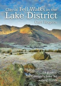 An authoritative new guide to the classic, ‘must do’ fell walking rounds in the Lake District. This pocket-sized guide is designed to be taken with you and outlines the many classic fell walking rounds to be enjoyed on the Lakeland fells.
 -
 by Vivienne Crow This exciting, new and interactive guide brings families with children ten of the very best family adventures in the Lake District National Park. With expertly-chosen adventures, superb photographs, clear information, an overview and introduction for each walk, expertly written numbered directions, large scale maps, and four themed interactive challenges for every adventure, these guides set a new standard in design, concept, clarity and ease-of-use.
 -
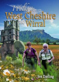 A Cheshire walking classic. With this book you’ll discover parts of Cheshire and Wirral you never knew existed. Ranging from 3-7 miles/5-11 kilometres in length, each of the walks features a reader-friendly factfile, clear route map and matching numbered walks directions, plentiful black and white and colour photographs, as well as fascinating snippets on local history, folklore, architecture and wildlife. Rewalked and revised 2021
 -
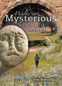 This new and wholly revised edition of a classic walking book contains fascinating, easy to follow walks exploring the unexpected past — from quiet strolls to hill and country rambles, by river, wood and ancient lane. A fascinating journey back in time ...
 -
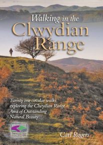 Walking in the Clwydian Range describes 21 circular walks spread throughout the AONB (Area of Outstanding Natural Beauty); many on the well known Offa’s Dyke Path, others in the little known country to the east of the main ridge. Some lovely walks.
 -
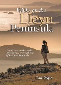 Walks on the Lleyn Peninsula contains 16 circular walks which explore some of the finest sectoins of the coast, along with several of lleyn’s shapely hills. With distances ranging from 1.5 – 7.25 miles, all walkers are catered for – from those looking for a casual half-day walk to add colour to a hoilday, to the more ambitious who may perhaps complete two or more routes as an alternative to Snowdonia. Understandably popular.
 -
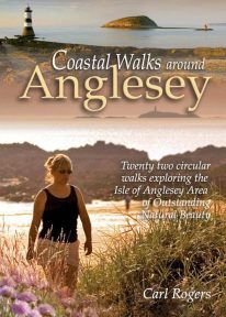 Coastal Walks around Anglesey contains 22 easy, circular walks that sample just about everything the island’s coastline has to offer. The routes have been chosen with all walkers in mind – from those looking for a casual half-day walk to add variety to a holiday, to the more ambitious who may complete two or more routes, perhaps as a less strenuous alternative to Snowdonia.
 -
Coming Soon
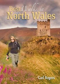 This authoritative walking guide will take you to some of the very best, tried-and-tested circular walking routes across NorthWales. The book covers walks in Anglesey, the Lleyn Peninsula, Snowdonia, the Conwy Valley, the Clwydian Range, and the Vale of Llangollen.
 -
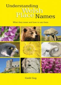 Puzzled by Welsh place names but want to know what they mean and how to say them? This fascinating, easy-to-use guide means non-Welsh speakers can now easily translate and understand place names all over Wales — on the map, on road signs, and out in the countryside. Armed with this insider knowledge, you’ll discover there’s a whole exciting new dimension to the Welsh landscape. In fact, Wales will never be quite the same again ….
 -
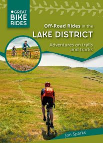 by Jon Sparks The second in a series of themed cycle guides to the Lake District, Off-Road Rides outlines a series of cycle rides filling the often-overlooked gap between easy forest roads and hardcore mountain biking. The routes seek out enjoyable tracks and trails, linked by quiet lanes. They include café and picnic stops, plus points of interest along the way.
 -
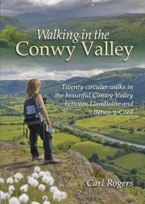 Twenty circular walks between Llandudno and Betws-y-Coed, in and around the beautiful Conwy Valley in eastern Snowdonia.
 -
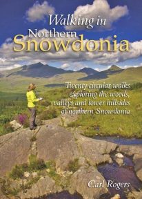 This attractive book explores twenty of the best low level circular walks in northern Snowdonia. Walking in Northern Snowdonia is dedicated to the northern half of the National Park, bounded by the Conwy Valley to the east, Glyn Lledr and the Vale of Ffestiniog to the south and Cwm Pennant to the west. Twenty circular walks are described, ranging in length from 4½ to 9 miles, which explore the woods, valleys and lower hillsides of this unique and beautiful area.
 -
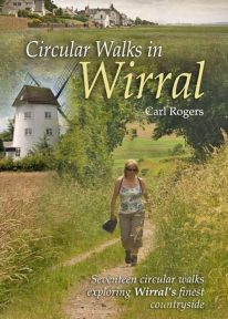 Circular Walks in Wirral will take you to some of Wirral’s most peaceful and scenic corners, and outlines 17 walks exploring Wirral's finest countryside spread throughout the peninsula.
 -
 The 30 short circular walks in this book have been written with the non-serious walker in mind, varying in length from just 1 to 4¾ miles (1.5km to 7.5km). Each walk has something of interest to discover — you will visit the site of an ancient port now completely dried out and over a mile inland; a seafront with neither sand nor sea; a wild, wooded river valley in the heart of industrial Merseyside and a lowland heath with wide views to the Welsh hills
 -
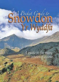 This book is a new and wholly updated edition of the popular, full-colour, handy sized guide to all of Snowdon’s recognised routes of ascent – from the six ‘Classic Paths’ to the many lesser known and less frequented routes.
 -
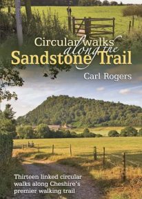 A popular classic Cheshire walking book. The Sandstone Trail runs for 34 miles/55 km along Cheshire’s wooded central sandstone ridge, and is one of Northwest England’s best-known and most popular walking routes.
 -
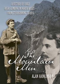 The fascinating inside story of pioneer rock climbers in Snowdonia, from the closing decades of the nineteenth century until the outbreak of the First World War.