


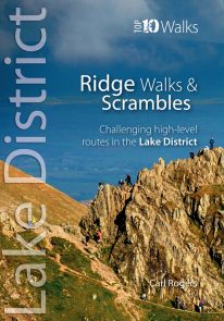
An authoritative new guide to the classic, ‘must do’ fell walking rounds in the Lake District.
This pocket-sized guide is designed to be taken with you and outlines the many classic fell walking rounds to be enjoyed on the Lakeland fells.
£9.99
Coming Soon
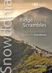
An authoritative new guide to the classic, ‘must do’ fell walking rounds in the Lake District.
This pocket-sized guide is designed to be taken with you and outlines the many classic fell walking rounds to be enjoyed on the Lakeland fells.
Coming Soon
An attractive new guide to the classic, ‘must do’ fell walking rounds.
This pocket-sized guide is designed to be taken with you and outlines the many classic fell walking rounds to be enjoyed on the Lakeland fells.
This authoritative map-pocket size book is aimed at the moderate to advanced user wanting complete circuits rather than detailed information on each fell. The book includes classics such as the Striding Edge/Swirral Edge round, the Coledale Horseshoe, Fairfield Horseshoe, Mosedale Horseshoe, Langdale Pikes, among many others.
A total of 78 Wainwrights are covered by the guide.
The book is also intended as an inspirational guide and uses lots of the author’s high quality photographs to inspire the user long before they set foot on the fells. Each route is shown on the relevant Ordnance Survey map, and includes information on distances, height gained and parking.
Prologue Introduction
The North
The West
The East
The South
| Summit | Section | Height | Route |
| Scafell Pike | The West | 978m/3,209ft | 8 |
| Scafell | The West | 964m/3,163ft | 9 |
| Helvellyn | The East | 950m/3,117ft | 12 |
| Skiddaw | The North | 931m/3,054ft | 2 |
| Great End | The West | 910m/2,986ft | 8 |
| Bowfell | The South | 902m/2,959ft | (18), 19 |
| Great Gable | The West | 899m/2,949ft | 11 |
| Pillar | The West | 892m/2,920ft | 10 |
| Catstycam | The East | 890m/3,156ft | 12 |
| Esk Pike | The South | 885m/2,904ft | 19 |
| Fairfield | The East | 873m/2,864ft | 13, 16 |
| Blencathra | The North | 868m/2,848ft | 1 |
| Crinkle Crags | The South | 859m/2,818ft | 18 |
| Grasmoor | The North | 852m/2,795ft | (3), 5 |
| St Sunday Crag | The East | 841m/2,759ft | 13 |
| Scoat Fell | The West | 841m/2,759ft | 10 |
| Crag Hill | The North | 839m/2,753ft | 3 |
| High Street | The East | 828m/2,717ft | 14, 15 |
| Red Pike | The West | 826m/2,710ft | 10 |
| Hart Crag | The South | 822m/2,697ft | 13, 16 |
| Steeple | The West | 819m/2,687ft | 10 |
| Lingmell | The West | 807m/2,648ft | 8 |
| High Stile | The West | 806m/2,644ft | 6 |
| Old Man | The South | 803m/2,635ft | 20 |
| Kirk Fell | The West | 802m/2,631ft | 11 |
| Swirl How | The South | 802m/2,631ft | 20 |
| Green Gable | The West | 801m/2,628ft | 11 |
| Brim Fell | The South | 796m/2,612ft | 20 |
| Dove Crag | The South | 792m/2,598ft | 16 |
| Rampsgill Head | The East | 792m/2,598ft | 14 |
| Grisedale Pike | The North | 791m/2,595ft | 3 |
| Thornthwaite Crag | The South | 784m/2,572ft | 15 |
| Great Carrs | The South | 780m/2,559ft | 20 |
| Kidsty Pike | The East | 780m/2,559ft | 14 |
| Harter Fell | The East | 778m/2,552ft | 14, 15 |
| Dow Crag | The South | 778m/2,552ft | 20 |
| Grey Friar | The South | 773m/2,536ft | 20 |
| Sail | The North | 773m/2,536ft | 3 |
| Wandope | The North | 772m/2,533ft | (3), 5 |
| Hopegill Head | The North | 770m/2,526ft | 5 |
| Great Rigg | The South | 766m/2,513ft | 16 |
| Mardale Ill Bell | The East | 760m/2,493ft | 14, 15 |
| Ill Bell | The South | 757m/2,484ft | 15 |
| Red Pike | The West | 755m/2,477ft | 6 |
| Slight Side | The West | 748m/2,454ft | 9 |
| Carl Side | The North | 746m/2,448ft | 2 |
| High Crag | The West | 744m/2,441ft | 6 |
| Robinson | The North | 737m/2,418ft | 4 |
| Harrison Stickle | The South | 736m/2,415ft | 17 |
| Long Side | The North | 734m/2,408ft | 2 |
| Kentmere Pike | The South | 730m/2,395ft | 15 |
| Hindscarth | The North | 727m/2,385ft | 4 |
| Thunacar Knotts | The South | 723m/2,372ft | 17 |
| Foswick | The South | 720m/2,362ft | 15 |
| Pike o’ Stickle | The South | 709m/2,326ft | 17 |
| Whiteside | The North | 707m/2,320ft | 5 |
| Yoke | The South | 706m/2,316ft | 15 |
| Pike o’ Blisco | The South | 705m/2,313ft | 18 |
| Pavey Ark | The South | 699m/2,298ft | 17 |
| Ullock Pike | The North | 690m/2,264ft | 2 |
| Loft Crag | The South | 680m/2,231ft | 16 |
| Scar Crags | The North | 672m/2,205ft | -3 |
| Whiteless Pike | The North | 660m/2,165ft | 5 |
| High Pike | The South | 656m/2,152ft | 16 |
| Fleetwith Pike | The West | 648m/2,126ft | 7 |
| Rossett Pike | The South | 648m/2,126ft | 19 |
| Causey Pike | The North | 637m/2,090ft | -3 |
| Yewbarrow | The West | 627m/2,057ft | 10 |
| Birks | The East | 622m/2,041ft | -13 |
| Heron Pike | The South | 612m/2,008ft | 16 |
| Haystacks | The West | 597m/1,959ft | 7 |
| Hartsop | The East | 579m/1,900ft | 13 |
| Shipman Knotts | The South | 587m/1,926ft | 15 |
| Outerside | The North | 568m/1,864ft | -3 |
| Low Pike | The South | 508m/1,667ft | 16 |
| Barrow | The North | 455m/1,493ft | -3 |
| Nab Scar | The South | 449m/1,473ft | 16 |
| Rannerdale Knotts | The North | 355m/1,165ft | 5 |
“With this eminently practical Pocket Fells guide Carl Rogers has achieved a superb evocation of precisely what constitutes a good fell day. Concise and visually captivating, the guide deserves to win many fans, especially from the new generation of mountain lovers as they learn how to get to grips with high places.”
—Mark Richards, author of Lakeland Fellranger guides
Only logged in customers who have purchased this product may leave a review.
Reviews
There are no reviews yet.