-
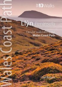 This handy little guide book gives you the ten very best short circular walks along the Llŷn peninsula section of the Wales Coast Path The Llŷn pushes 30 miles into the Irish Sea, tipped by the holy isle of Bardsey, or Ynys Enlli — ‘the island of 20,000 saints’. This remote and unspoilt landscape is characterised by traditional farms and compact villages, punctuated by volcanic hills. Its relative isolation has made it a haven for the Welsh language and culture. Sea cliffs, offshore rocks and intimate coves dominate the northern coast, while the gentler southern coast promises sandy beaches and holiday towns like Abersoch and Pwllheli. But for sheer beauty, tranquillity and wildlife, the Llŷn is hard to beat.
 -
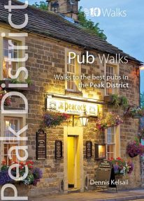 This handy pocket size book will take you on short circular walks to the ten best pubs in the Peak District. Ever since rambling became a recognised pastime, country pubs have been magnets for walkers. Whether a lunch-time stop along the way or a final destination for the day, the promise of a thirst-quenching pint or a hearty meal are, for many, an integral part of the day. Many of Peakland’s inns have their origins in serving the jaggers and stockmen who travelled the lonely upland routes. Today, they serve not only the locals but also the growing influx of recreational visitors. Long live the Peak District pub.
 -
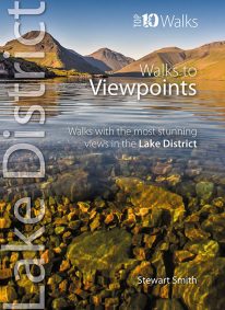 When it comes to hill walking, walks with views are much more fun than those without. These walks will also take keen photographers to come of the best places in Cumbria for taking those stunning images. Viewpoints are the walkers reward: the potential grandeur of the vista or panorama from just over the next incline or the atop the next crag is the incentive that draws on weary legs to summits. With lakes, rivers, forests, woodland, rolling countryside and craggy fells all crammed into such a compact geographical area, it’s no surprise that the Lake District is full of such stunning visual rewards, with unique and beautiful views around every corner.
 -
 Even the Peak District's name conceals a mystery. Forget the obvious: a visitor expecting towering peaks will be disappointed, as the name comes from the Pecsaetan tribe who once lived here. But there’s a twist: the Anglo-Saxon means “settlers of the Pec”…and that word pec has the same root as our peak, the dialect pike and the Pyrenean pic. So, ultimately, the Peak District is named after its peaks, after all. The Peak District is broadly defined by the conurbations at its corners: Manchester, Sheffield, Derby and Stoke. Within this rectangle, the National Park forms a rough oval of around 550 square miles. The area is traditionally divided into the Dark Peak – peat moorland edged by gritstone, with rugged villages in the valleys — and the softer White Peak - upland pastures defined by drystone walls, divided by gorges and limestone villages. The eastern and western moors are similar to the Dark Peak, but have their own subtly distinctive characters. The Peak District was occupied by humans long before the Pecsaetans and in each era man has left his mark, from prehistoric standing stones and rock art, through the folk legends, crosses and churches of the Middle Ages, to post-medieval follies and puzzling relics of the extraction of lime and lead. The varied geology of the area throws up natural curiosities too: its dark gritstone has wind-sculpted tors and edges, while its gleaming limestone hides caves and subterranean rivers. This handy pocket size book will take you on short circular walks to the ten most fascinating, odd or strange places in the Peak District. Prepare to be amazed and surprised.
 -
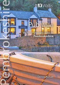 This attractive and good looking book will take you on ten short circular walks to some of the finest and most iconic pubs and inns in Pembrokeshire, in South Wales. Ever since rambling became a recognised pastime, country pubs have been magnets for walkers. Whether a lunchtime stop along the way or a final destination for the day, the promise of a thirst-quenching pint, bar snack or a hearty meal is for many, an integral part of the day. Many of Pembrokeshire's coastal inns have origins in serving seafarers, while those inland lay beside routes to and from the coast or beside old droves along which livestock were herded to market. Today, all have a fine tradition of serving visitors who come for no other purpose than to enjoy the magnificent countryside. Those chosen here have long established reputations for their food or ale and have an individual quirkiness worth seeking out.
 -
Coming Soon
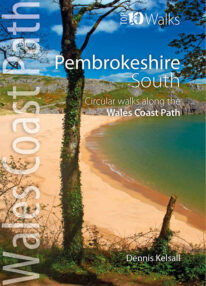 This lovely little book explores the ten best short circular walks along the southern part of the Pembrokeshire coast — itself part of the Wales Coast Path. The Pembrokeshire coast alters subtly from north to south. The southern rocks are far younger and the coast tends to be south-facing, too, creating a gentler hinterland. This influenced historical development and culture, for although the Norman advance extended throughout Pembrokeshire, settlement focused on the more fertile southern corner. It became known as ‘Little England’, with English rather than Welsh spoken, a tradition reflected in place names. Before reliable roads, trade and prosperity favoured the coast, and because the railways came late here, Pembrokeshire was largely ignored by the Industrial Revolution. Unspoiled and breathtakingly scenic, the coast is captivating every step of the way.
 -
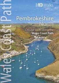 This photogenic book will take you on ten short circular walks along the northern part of the Pembrokeshire section of the Wales Coast Path. Pembrokeshire’s north coast has a rugged and remote quality, reflecting the wildness of the hills that rise behind. It was largely ignored during the Norman colonisation and even today beyond St Dogmael’s there are only a handful of coastal communities. Yet burial cairns, promontory forts and a pre-historic trackway across the Preseli Hills indicate widespread prehistoric settlement, and it was an important focus during the spread of Celtic Christianity. Fishing, farming and stock grazing were traditional ways of life, but the Industrial Revolution briefly opened coastal quarrying and the railway made Fishguard an important Irish port. Today, it is a relative backwater but the coast has an untamed beauty, its flowers, birds, seals and porpoises making it a truly special place.
 -
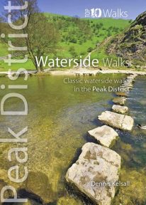 This pocket size book explores the ten best short circular waterside walks in the Peak District. Some follow lovely stretches of rivers; others explore the northern reservoirs. Several major rivers originate in the Peak, fed by countless springs, brooks and streams that have cut deep cloughs and gorges through the grit and limestone. Many powered the early industrialisation of the area while the valleys often served as conduits for trans-Pennine trade. Other dales, too steep or narrow for settlement or farming, or whose streams found subterranean courses, were ignored and today provide valuable wildlife habitats. And although the region has no significant natural lakes, reservoirs abound and are now largely naturalised within the landscape.
 -
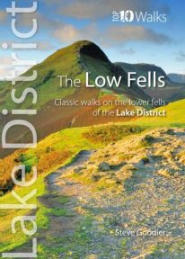 This superb pocket size book will take you on ten short circular walks to the ten best-known low fells in the Lake District The fells get their name from the Old Norse word, fjalls, which originally meant areas of rough upland grazing. Today, the Lakeland fells promise some of the best high level walking in England, and a real sense of freedom. But though the high fells often feature rocky summits, narrow edges and sheer cliffs, the lower fells, below the 2,000 foot contour, are greener, rounder and kinder. Walking on them can still be steep and strenuous, of course, but the routes are more suitable for the general walker. And the views are just as incredible.
 -
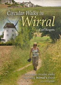 Circular Walks in Wirral will take you to some of Wirral’s most peaceful and scenic corners, and outlines 17 walks exploring Wirral's finest countryside spread throughout the peninsula.
 -
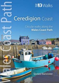 This handy pocket size book will take you on ten of the best short circular walks along the Ceredigion coast. Cardigan Bay embraces the dramatic sweep of the Welsh coastline, from Bardsey Island on the tip of the Llŷn in the north, to Strumble Head in Pembrokeshire in the south. It takes in parts of two National Parks: Snowdonia and Pembrokeshire, and three different counties: Gwynedd, Ceredigion and Pembrokeshire. The southern half of Cardigan Bay covers the rugged coastline between Aberystwyth and Cardigan. The dramatic cliffs and hidden coves are part of the Ceredigion Coast Path: a 60 mile trail that promises stunning views and some of the best opportunities for walkers to spot maritime wildlife in Wales.
 -
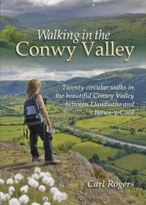 Twenty circular walks between Llandudno and Betws-y-Coed, in and around the beautiful Conwy Valley in eastern Snowdonia.