-
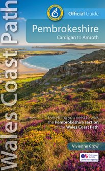 NEW, updated and revised edition - 2021 One of seven Official Guides to the Wales Coast Path The 186 mile/300km long Pembrokeshire section of the Wales Coast Path runs through some of Wales’ most varied and dramatic coastal scenery — high, rugged cliffs and long sandy bays, Pembroke Castle, St David’s cathedral and St Govan’s remote cliff-wrapped chapel, with several large offshore islands. Pembrokeshire is also Britain’s only coastal National Park. This Official Guide splits the route into 14 convenient day sections, each of about 10-17 miles / 16-27 kilometres. It contains everything local and long-distance walkers need to enjoy the path.
 -
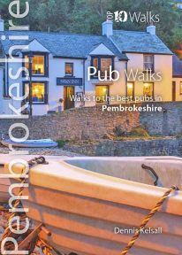 This attractive and good looking book will take you on ten short circular walks to some of the finest and most iconic pubs and inns in Pembrokeshire, in South Wales. Ever since rambling became a recognised pastime, country pubs have been magnets for walkers. Whether a lunchtime stop along the way or a final destination for the day, the promise of a thirst-quenching pint, bar snack or a hearty meal is for many, an integral part of the day. Many of Pembrokeshire's coastal inns have origins in serving seafarers, while those inland lay beside routes to and from the coast or beside old droves along which livestock were herded to market. Today, all have a fine tradition of serving visitors who come for no other purpose than to enjoy the magnificent countryside. Those chosen here have long established reputations for their food or ale and have an individual quirkiness worth seeking out.
 -
Coming Soon
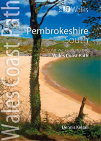 This lovely little book explores the ten best short circular walks along the southern part of the Pembrokeshire coast — itself part of the Wales Coast Path. The Pembrokeshire coast alters subtly from north to south. The southern rocks are far younger and the coast tends to be south-facing, too, creating a gentler hinterland. This influenced historical development and culture, for although the Norman advance extended throughout Pembrokeshire, settlement focused on the more fertile southern corner. It became known as ‘Little England’, with English rather than Welsh spoken, a tradition reflected in place names. Before reliable roads, trade and prosperity favoured the coast, and because the railways came late here, Pembrokeshire was largely ignored by the Industrial Revolution. Unspoiled and breathtakingly scenic, the coast is captivating every step of the way.
 -
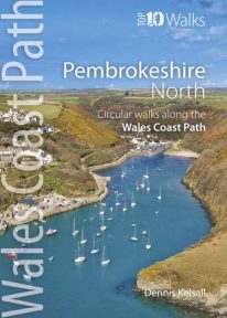 This photogenic book will take you on ten short circular walks along the northern part of the Pembrokeshire section of the Wales Coast Path. Pembrokeshire’s north coast has a rugged and remote quality, reflecting the wildness of the hills that rise behind. It was largely ignored during the Norman colonisation and even today beyond St Dogmael’s there are only a handful of coastal communities. Yet burial cairns, promontory forts and a pre-historic trackway across the Preseli Hills indicate widespread prehistoric settlement, and it was an important focus during the spread of Celtic Christianity. Fishing, farming and stock grazing were traditional ways of life, but the Industrial Revolution briefly opened coastal quarrying and the railway made Fishguard an important Irish port. Today, it is a relative backwater but the coast has an untamed beauty, its flowers, birds, seals and porpoises making it a truly special place.
 -
 Pembrokeshire’s Café Culture is booming and it’s not the big chains leading the way. Gone are the steamy fugs, greasy-spoon menus and chipped mugs; instead, there’s no shortage of bright and friendly venues serving speciality coffees and teas, home-made baking, and wonderful snacks and meals that capitalise on the best of local produce and culinary talent. Very often there’re take-away options too and sometimes interesting wines or Welsh-brewed beers and ciders. Many are open all day from breakfast and morning coffee to afternoon tea, with some venues running into the evening too with live music, poetry or storytelling. They’re great places to rest or meet up with friends, too; so go for a walk and see what you can find — you’ll not be disappointed.
 -
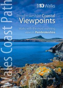 by Dennis Kelsall This attractive and good looking book will take you on ten short circular walks to some of the finest and most iconic views and viewpoints along the rugged Pembrokeshire coast, in West Wales. For some hillwalkers, the ‘view’ is only achieved on attaining the summit. But here, the endless convolutions of the coastline create an ever changing scene, both in front and behind; with every step shifting the perspective, bringing something different into sight. While the distant view can stretch for miles, inlets, coves and bays may remain hidden, only revealing themselves at the last moment. More immediately, the cliffs are broken by crevices, ledges, caves and natural arches, while just offshore are stacks and wave-washed shoals. Behind, the hinterland is a patchwork of hill, common and agriculture, while the vista out to the sea is endlessly changed by the weather, tide and hour. And, where accessible, the prospect from the beach is different again. Memorable walks to unmissable views.
 -
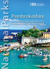 by Dennis Kelsall This superbly-written and good looking book will take you on ten short circular walks to the very best stretches of coast, pubs, tea shops, and viewpoints that the beautiful Pembrokeshire coast, in West Wales, has to offer. Defining the south-westernmost tip of Wales, Pembrokeshire’s coastline is arguably the most beautiful and varied in the British Isles. Virtually all of it lies within the Pembrokeshire Coast National Park. Relative isolation has left it largely untouched by modern development and most of its length is a wild frontier where the endless confrontation between sea and land is played out. Long stretches of coast face the fury of Atlantic storms and weakness and faults in the high cliffs are eroded into caves, coves and inlets. However, the harder rock, some of which is 700 million years old, resists the onslaught and stands out in rugged promontories and headlands. Elsewhere, sheltered landings and harbours, fine beaches and secluded bays reveal other aspects of this glorious landscape. In spring and summer the cliff tops break out in the pink, blue, white and yellow of countless flowers and sea crags are alive with nesting birds, while some of Britain’s largest seal populations arrive in autumn to give birth. It was this wild beauty that prompted the establishment of the Pembrokeshire Coast National Park in 1952. Despite being one of the UK’s smaller National Parks, it embraces a third of the county including all the offshore islands, the Daugleddau estuary, and the Preseli Hills. The Park is also home to the popular Pembrokeshire Coast Path — now part of the larger Wales Coast Path. Discover dramatic coastlines at St Davids Head and Strumble Head, Manorbier and Tenby. Climb to lofty coastal panoramas at Carn Ingli and Carn Llidi. Enjoy characterful waterside pubs at Porthgain and Cresswell Quay. Or relax over a quiet cup of coffee or tea and cake at two of Pembrokeshire’s cosiest and most welcoming tea shops and cafés. Unmissable.
 -
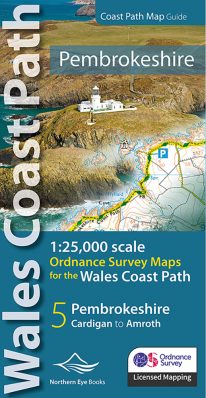 Enhanced, large scale (1: 25,000) Ordnance Survey mapping in a handy atlas format with all the mapping you need to walk a complete Pembrokeshire coast section of the Wales Coast Path. Continuous OS mapping covering the complete route from St Dogmael's near Cardigan to Amroth, on the Carmarthenshire border. Contains generous coastal extracts from large-scale OS Explorer maps OL 35 and OL36. The Pembrokeshire Coast Ordnance Survey mapping book is part of a series of map atlases covering the whole of the 870-mile long Wales Coast Path. The enhanced OS 1:25,000 maps are accurate, up-to-date and reliable. Additional map symbols show tea shops, cafes, extra parking, and public toilets. A brief introduction to the Pembrokeshire Coast includes a fascinating photo mosaic highlighting notable views, places of interest and wildlife you'll meet along the way. There is also a section of detailed Useful Information at the back of the atlas. Laminated flapped covers showing Wales Coast Path signs and waymarkers, route details and map symbols make these atlases simple and easy to use. The map books’ dimensions are 215mm x 107mm and they fit easily into a standard map pocket.
- Large scale Ordnance Survey Explorer mapping for the complete North Wales Coast in a handy atlas format.
- Highlighted official route of the Wales Coast Path.
- On-map symbols showing amenities at main towns and villages.
- Introduction with attractive photo mosaic.
- Additional useful information